Fast field data collection

Trimble's sophisticated TSC3 controller is designed to allow surveyors and geospatial professionals to collect, share and deliver data. This unit is said to improve accuracy, efficiency and productivity between the field and office and is designed to be used with the Trimble Access software. The TSC3 controller offers fast and reliable data collection, computing and connectivity capabilities and provides multiple functions in a single handheld device. The unit incorporates a digital camera, integrated commu
February 10, 2012 Read time: 2 mins
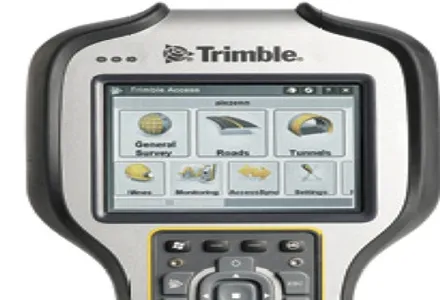
2122 Trimble's sophisticated TSC3 controller is designed to allow surveyors and geospatial professionals to collect, share and deliver data. This unit is said to improve accuracy, efficiency and productivity between the field and office and is designed to be used with the Trimble Access software. The TSC3 controller offers fast and reliable data collection, computing and connectivity capabilities and provides multiple functions in a single handheld device. The unit incorporates a digital camera, integrated communications as well as a GPS navigator, compass and accelerometer.

Using this device, surveyors can include on-site photos in surveys, communicate efficiently between field and office and streamline stakeout activities. The durable Trimble TSC3 controller has a high-resolution, sunlight-readable touchscreen display, integrated Wi-Fi and Bluetooth wireless capabilities and long battery life. Users can also choose either a QWERTY or ABC alphanumeric keyboard.

Delivered with Trimble Access software installed as well as the capability to run third-party applications on the Windows platform, the TSC3 is a comprehensive data collection solution for the survey industry. The Trimble TSC3 controller has wireless Internet connectivity through either the integrated GSM/GPRS modem or Wi-Fi. Data collection, processing, analysis, and delivery duties are said to be faster and more efficient.

For more information on companies in this article

Related Content

  • Mobile mapping innovation
    June 1, 2022
    There are millions of kilometres of roads and features that need to be mapped in today’s world. We see a strong vision and application for the future, therefore Leica Geosystems, part of Hexagon, recently announced the introduction of the reality capture mobile mapping system Leica Pegasus TRK, introducing artificial intelligence, autonomous workflows and intuitive interfaces. This technology goes beyond the capabilities of what’s already been done, making it the perfect companion for today’s mobile mapping requirements.
  • The era of workzone data
    July 4, 2018
    Portable work zone messaging is now integral - not an add-on - when it comes to safety on large-scale highway projects. Andrew Williams* reports. Portable work zone ITS solutions have emerged in recent years as important flexible tools for managing major roadwork projects, from new-build to upgrades. They effectively ensure traffic disruption is kept to a minimum and lives can be saved. As such, the technology forms a central component of a major €1.7 billion project in the southern English county of Cambr
  • Accurate asphalt compaction
    July 21, 2022
    The latest compaction package from Trimble helps to deliver a quality surface more quickly and efficiently. According to the firm, the system allows operators to accurately control the compaction process, while reducing unnecessary passes that can result in over compaction.
  • Trimble is offering more sophisticated GNSS receivers
    January 6, 2017
    Trimble says that it is increasing the capabilities of its integrated GNSS survey receiver range. This line-up includes the Trimble R4, Trimble R6, Trimble R8 GNSS systems and is rounded out by the latest Trimble R10 GNSS System. The new improvements being added include increased satellite tracking and Real Time Kinematic (RTK) performance. These modernise the integrated receiver portfolio to add functionality, flexibility and capability as well as providing more options for surveyors.