Accurate positioning with Topcon

By Topcon March 13, 2024 Read time: 1 min
Topcon says that its new Hybrid Positioning package offers versatility for positioning and optical robotic measurements

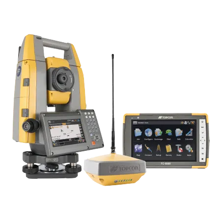
The new Hybrid Positioning system from Topcon is said to perform faster in the field than stand-alone robotic systems and is more versatile than RTK-only solutions. The latest Hybrid Positioning technology combines GNSS positioning and optical robotic measurements on one rover pole.

The unit offers a robotic total station and a lightweight GNSS receiver in a single package and is said to allow faster field work than stand-alone robotic or GNSS solutions. The system has a hybrid lock for rapid prism acquisition in dense areas and a hybrid switch for bouncing between optical measurements and GNSS positioning, as well as a hybrid resection to start set up at a safe and convenient location.

The system is compatible with all Topcon robotic total stations and allows the user to reacquire targets even in challenging conditions. A user can can select safe, convenient locations and define the unknown point of the instrument from GNSS measurements. The firm says that for maximum efficiency, users can pair the Hybrid Positioning technology with MAGNET Field data-collection software.
 

For more information on companies in this article

Related Content

  • Machine control advances boosting quality
    June 12, 2017
    The latest developments in machine control technology will deliver major gains in quality and productivity. Machine control technology plays an increasingly important role in construction. The pace of development has been fast, with new systems offering major gains in both productivity and quality across a range of applications. At the recent CONEXPO-CON/AGG 2017 exhibition in Las Vegas, key advances were unveiled in machine control technologies suited to markets such as earthmoving, concrete paving and pil
  • Topcon’s LN-100 3D positioning system
    May 13, 2014
    Topcon Positioning Group says its new BIM solution - the LN-100 – is the world’s first 3D positioning system designed specifically for construction layout. Said to offer seamless integration and flow of project data from the design to the field, the LN-100 is simple to operate, removing “the intimidation factor and reducing the learning curve in performing construction layout tasks,” according to Eduardo Falcon, Topcon Positioning Group executive vice president and general manager for the GeoPositioning
  • Laser scanning focuses on asset management
    January 9, 2015
    Laser scanners and improved data collection and analysis software are making light of asset management surveying. David Arminas reports The age of the laser scanner is upon us, taking over from traditional manual methods of surveying, data collection and processing. These new technical developments are making it much easier to process and use the data captured and are providing highways engineers with powerful tools to record, map and visualise their assets. This is good news for highways authorities
  • Sophisticated software solutions offering surveying innovation and construction efficiency
    August 28, 2014
    An array of new software tools will deliver greater efficiencies to construction companies – Mike Woof writes. Sophisticated software systems are delivering advanced solutions to traditional construction tasks. Key developments have been made by major players in the sector, such as Bentley Systems, Fugro Roadware, Leica Geosystems and Topcon Sokkia. From Bentley comes a new package that will help road construction activities in urban areas featuring a heavy concentration of underground utilities. This n