
Accurate positioning with Topcon

By Topcon March 13, 2024 Read time: 1 min
Topcon says that its new Hybrid Positioning package offers versatility for positioning and optical robotic measurements

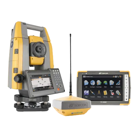
The new Hybrid Positioning system from Topcon is said to perform faster in the field than stand-alone robotic systems and is more versatile than RTK-only solutions. The latest Hybrid Positioning technology combines GNSS positioning and optical robotic measurements on one rover pole.

The unit offers a robotic total station and a lightweight GNSS receiver in a single package and is said to allow faster field work than stand-alone robotic or GNSS solutions. The system has a hybrid lock for rapid prism acquisition in dense areas and a hybrid switch for bouncing between optical measurements and GNSS positioning, as well as a hybrid resection to start set up at a safe and convenient location.

The system is compatible with all Topcon robotic total stations and allows the user to reacquire targets even in challenging conditions. A user can can select safe, convenient locations and define the unknown point of the instrument from GNSS measurements. The firm says that for maximum efficiency, users can pair the Hybrid Positioning technology with MAGNET Field data-collection software.
 

For more information on companies in this article

Related Content

  • Leica Captivate Experience works with fifth generation of ATRplus
    August 17, 2015
    Leica Geosystems says its Leica Captivate Experience creates highly realistic 3D models that enables professionals to capture and manage complex data easily and accurately. With little more than a swipe, users can now navigate through customisable apps containing information for multiple projects. Advanced lining and coding provide an interactive 3D model where users can zoom, pan and orbit the rendering for optimal viewing and manipulation. “Leica Geosystems has taken a giant leap forward with Captiv
  • It’s a level playing field with Leica’s iCON gps 70 Series
    April 27, 2018
    Efficiency is the name of the game from the iCON gps 70 Series, a GNSS rover from Leica Geosystems. With the iCON gps 70 T you can measure and stakeout points faster and without the need to keep the pole vertical and level the bubble. The combination of the latest GNSS technology and inertial measurement unit (IMU) equips the iCON gps 70 T with permanent tilt compensation and makes it resistant to any magnetic interference. Because the iCON gps 70 T is calibration-free, it can be ready instantly and any
  • Data collection key to software developments
    February 13, 2012
    The collection and handling of data are key technology drivers in the software sector. New methods of data collection and manipulation are driving significant developments in software at present. The latest technology allows designers and engineers to collect, store and manipulate ever larger amounts of data. Growing use of mobile field equipment for both data collection and field management is driving interactive systems. And in an interview this month Autodesk senior vice-president for the construction an
  • Easy to use stringless concrete paving systems
    February 14, 2012
    Stringless concrete paving systems are easy to use for contractors - Daniel C Brown. With just a few days of training, Hawkins Construction is now up and running with stringless concrete paving technology. This year Hawkins started using the stringless technology on two Interstate highway paving projects, with a total contract value of US$78 million. The projects were on I-80 between Omaha and Lincoln, Nebraska and the first section was for a 9.25km, 18.3m wide stretch of 330mm thick concrete pavement.