Accurate positioning with Leica Geosystems

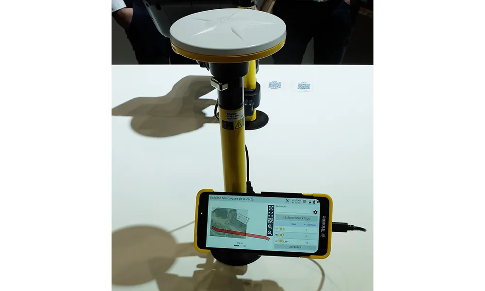
The new Zeno GG04 smart antenna from Leica Geosystems is said to increase access to GIS and boost tracking performance. This is said to deliver a versatile solution that can improve the accuracy of GNSS mobile devices with real-time Kinematic (RTK) and precise point positioning (PPP). Paired with the Zeno GG04, any Zeno or third party mobile device with Android or Windows OS can now collect precise positioning data with Leica Geosystems’ GNSS technology and 555-channel tracking performance. With PPP, users
June 19, 2017 Read time: 2 mins
The new smart antenna from Leica Geosystems offers increased tracking accuracy
The new Zeno GG04 smart antenna from Leica Geosystems is said to increase access to GIS and boost tracking performance.


This is said to deliver a versatile solution that can improve the accuracy of GNSS mobile devices with real-time Kinematic (RTK) and precise point positioning (PPP).

Paired with the Zeno GG04, any Zeno or third party mobile device with 1223 Android or Windows OS can now collect precise positioning data with 265 Leica Geosystems’ GNSS technology and 555-channel tracking performance. With PPP, users can collect data even in areas without cellular coverage. The bring-your-own-device (BYOD) functionality enables any smart device to collect survey-grade data, delivering centimetre results.

With the Zeno Connect app, any third-party app is compatible with the Zeno GG04 smart antenna. The Zeno Mobile, Zeno Connect or 212 Esri’s Collector for ArcGIS apps provide an easy and familiar platform for non-surveying professionals to collect and analyse data. Organisations can integrate and optimise data in real time from different sources to collect all details of any project from anywhere in the world.

For more information on companies in this article

Related Content

  • Road user subscriptions will fund the road ecosystems of the future says ERF Lab
    December 14, 2018
    The highway of the future will not be a physical asset created and maintained by the construction industry … it will increasingly be seen as part of an emerging global services sector. “Every day we hear about Mobility as a Service (MaaS), but what about Roads as a Service?” says Christophe Nicodème, general director of the European Union Road Federation (ERF). “The role of the road is changing. We need to think much more carefully about planning (highway) infrastructure in terms of people’s needs. We must
  • Growing WIM demand in Russia and South America
    April 4, 2014
    One Eastern European WIM manufacturer is finding commercial success in Russia, while another leading manufacturer is in demand in South America, as Guy Woodford reports Since Czech WIM technology manufacturer Camea secured type approval for its UnicamWIM system in early 2013, the firm has been installing a number of the systems in different Russian regions. These have included two UnicamWIM stations in Novosibirsk, one in the Kostroma region, and another on the M20 Highway between Belarus and Russia.
  • Using technology so assess road surface quality
    April 4, 2014
    Advances in survey technology and the evolving face of road procurement are driving demand for highway condition data. Mark Thomas, infrastructure services manager at Fugro Aperio writes how surveys of new roads can improve long-term quality While a growing suite of non-intrusive testing, measurement and survey technologies are widely used to target highway repairs and to determine asset management strategies, the use of these powerful tools remains patchy in the early stages of the infrastructure life cycl
  • Trimble and OEMs extend technology deal
    December 13, 2024
    Trimble is extending its technology deals with Caterpillar and John Deere.