Savoy swept-path

Savoy Computing in the UK has been quick to launch a new version of its AutoTrack swept-path analysis software to take advantage of the latest AutoCAD 2012 platform.
February 21, 2012 Read time: 2 mins
2902 Savoy Computing in the UK has been quick to launch a new version of its AutoTrack swept-path analysis software to take advantage of the latest AutoCAD 2012 platform.

AutoTrack v9.10 has full native support for all AutoCAD 2012 and the products that sit above it such as Civil 3D in 32-bit and 64-bit variants.

A key feature now is that the drawing algorithms in AutoTrack take advantage of speed enhancements in AutoCAD, especially the temporary graphics displayed while grip editing and dragging. It gives a much more responsive feel says Savoy.

A context-sensitive AutoTrack ribbon has been programmed in so that clicking an AutoTrack object will automatically display the AutoTrack menu ribbon.

BLOB, Savoy's swept-path analysis software, is to be sold in Brazil by N A Tecnologia which becomes an authorised distributor and Savoy Partner. The Brazilian firm provides software, support and training to engineers in Brazil and South America.

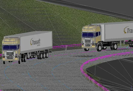
Canadian software house 349 Transoft Solutions has taken vehicle swept-path analysis to a new level with the launch of a three-dimensional version of its AutoTURN analyser.

AutoTURN Pro 3D is based on the same calculation engine as the original program, now in version 8, but works with a three-dimensional design view of a road and its junctions based on a digital terrain model. Alternatively a 2D design can be projected onto a DTM says Transoft.

Using a set of special tools the user pulls along a vehicle selected from an extensive library of international vehicle types which the firm says are accurate in detail and dimensions, and the program then calculates the swept-path both horizontally and vertically, alerting the designer to obstacles and terrain conflicts.

It finds ground clearance, distance to objects and height limitations.

A punch-through cross-section can be seen at any point and the program can be used for visualisations for client presentations after the design has been tweaked.





For more information on companies in this article

Related Content

  • Bentley’s OpenBridge for Cebu-Cordova link
    February 7, 2024
    The OpenBridge software solution from Bentley Systems played a key role in the development of the Cebu-Cordova bridge project in the Philippines.
  • In control - with machine control technology
    June 21, 2016
    Advances with machine control technologies are providing major benefits right across the construction sector - Mike Woof writes With the massive bauma 2016 exhibition now having run its course, the construction sector look set to benefit from a range of new machine control technologies. These systems are being offered across a range of different segments in the equipment sector. Bulldozing was one of the first portions of the earthmoving segment to benefit from machine control systems, but a vast array o
  • Improved roadmarkings will boost roadway safety for users
    February 19, 2013
    An Innovative road marking system helping to boost public transport in a major South American city, and road marking analytic technology robust enough to withstand damage in heavy rain are among products examined by Guy Woodford . DEGAROUTE Methacylate (MMA) cold plastic area markings from Evonik Industries are being used as part of efforts to improve the public transport system in Santiago, Chile. By adding red pigment to the DEGAROUTE binder, distinctive and long-lasting red-coloured bus lanes are being c
  • Positioning tools continue to improve
    July 16, 2012
    Topcon says that its new IP-S2 package combines GNNS positioning capabilities with inertial sensors, while the firm also has a solution for customers wanting to mix and match receiver components. The IP-S2 is a vehicle-mounted, mobile 3D tool that offers precision mapping and surveying capabilities. The package collects data using 3D laser scanners, LIDAR, and/or cameras, and this is then integrated, time-stamped and geo-referenced. The customer can use this assembled data to combine LIDAR point cloud and d