Savoy swept-path

Savoy Computing in the UK has been quick to launch a new version of its AutoTrack swept-path analysis software to take advantage of the latest AutoCAD 2012 platform.
February 21, 2012 Read time: 2 mins
2902 Savoy Computing in the UK has been quick to launch a new version of its AutoTrack swept-path analysis software to take advantage of the latest AutoCAD 2012 platform.

AutoTrack v9.10 has full native support for all AutoCAD 2012 and the products that sit above it such as Civil 3D in 32-bit and 64-bit variants.

A key feature now is that the drawing algorithms in AutoTrack take advantage of speed enhancements in AutoCAD, especially the temporary graphics displayed while grip editing and dragging. It gives a much more responsive feel says Savoy.

A context-sensitive AutoTrack ribbon has been programmed in so that clicking an AutoTrack object will automatically display the AutoTrack menu ribbon.

BLOB, Savoy's swept-path analysis software, is to be sold in Brazil by N A Tecnologia which becomes an authorised distributor and Savoy Partner. The Brazilian firm provides software, support and training to engineers in Brazil and South America.

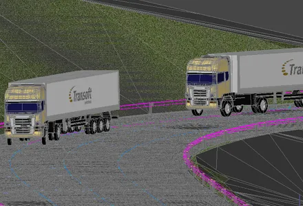
Canadian software house 349 Transoft Solutions has taken vehicle swept-path analysis to a new level with the launch of a three-dimensional version of its AutoTURN analyser.

AutoTURN Pro 3D is based on the same calculation engine as the original program, now in version 8, but works with a three-dimensional design view of a road and its junctions based on a digital terrain model. Alternatively a 2D design can be projected onto a DTM says Transoft.

Using a set of special tools the user pulls along a vehicle selected from an extensive library of international vehicle types which the firm says are accurate in detail and dimensions, and the program then calculates the swept-path both horizontally and vertically, alerting the designer to obstacles and terrain conflicts.

It finds ground clearance, distance to objects and height limitations.

A punch-through cross-section can be seen at any point and the program can be used for visualisations for client presentations after the design has been tweaked.


For more information on companies in this article

Related Content

  • TomTom maps cover over 35 million kilometres
    May 4, 2012
    TomTom has announced the availability of its latest map and enhancement product portfolio, delivering new coverage and features. With the addition of 400,000 kilometres across the globe, the company claims its navigable map database is the first to reach 35.2 million kilometres of roads, covering 104 countries and a record 3.4 billion people worldwide.
  • Improving workflows with Softree
    July 26, 2023
    Softree Technical Systems says that its new RoadEng Civil Engineer software focuses on simplifying workflows and improving visualisation.
  • Cultivate better on-site safety awareness by leveraging technology with Leica Geosystems
    August 10, 2023
    When a vital fiber-optic cable was cut during construction work in Germany, the impact was huge. There were telecom disruptions affecting the greater Frankfurt area, all departures and landings at Frankfurt Airport were suspended, and Lufthansa’s global IT system crashed. Leica Geosystems says it is vital to put in place “strategies to protect people, equipment, and assets… and to emphasise the crucial role digital solutions play in ensuring safety.”
  • Construction adapting with Machine control Technologies
    June 18, 2015
    Machine control technologies are revolutionising construction – Dan Gilkes writes Electronic control of engines, transmissions and hydraulic systems, primarily to reduce exhaust emissions and boost productivity, is also providing manufacturers with an opportunity to incorporate increasingly complex machine control into their equipment. This in turn has the potential to make the machinery more productive, further cutting fuel consumption as part of a virtuous operational circle.