Savoy swept-path

Savoy Computing in the UK has been quick to launch a new version of its AutoTrack swept-path analysis software to take advantage of the latest AutoCAD 2012 platform.
February 21, 2012 Read time: 2 mins
2902 Savoy Computing in the UK has been quick to launch a new version of its AutoTrack swept-path analysis software to take advantage of the latest AutoCAD 2012 platform.

AutoTrack v9.10 has full native support for all AutoCAD 2012 and the products that sit above it such as Civil 3D in 32-bit and 64-bit variants.

A key feature now is that the drawing algorithms in AutoTrack take advantage of speed enhancements in AutoCAD, especially the temporary graphics displayed while grip editing and dragging. It gives a much more responsive feel says Savoy.

A context-sensitive AutoTrack ribbon has been programmed in so that clicking an AutoTrack object will automatically display the AutoTrack menu ribbon.

BLOB, Savoy's swept-path analysis software, is to be sold in Brazil by N A Tecnologia which becomes an authorised distributor and Savoy Partner. The Brazilian firm provides software, support and training to engineers in Brazil and South America.

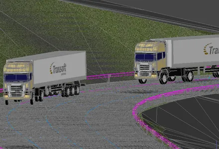
Canadian software house 349 Transoft Solutions has taken vehicle swept-path analysis to a new level with the launch of a three-dimensional version of its AutoTURN analyser.

AutoTURN Pro 3D is based on the same calculation engine as the original program, now in version 8, but works with a three-dimensional design view of a road and its junctions based on a digital terrain model. Alternatively a 2D design can be projected onto a DTM says Transoft.

Using a set of special tools the user pulls along a vehicle selected from an extensive library of international vehicle types which the firm says are accurate in detail and dimensions, and the program then calculates the swept-path both horizontally and vertically, alerting the designer to obstacles and terrain conflicts.

It finds ground clearance, distance to objects and height limitations.

A punch-through cross-section can be seen at any point and the program can be used for visualisations for client presentations after the design has been tweaked.




For more information on companies in this article

Related Content

  • Noise mapping software from SoundPLAN
    October 27, 2016
    Software specialist SoundPLAN is now offering the latest version of its sophisticated noise-mapping package worldwide. The 4.0 package has been trialled in Germany and can be used to calculate the noise emissions from roads and other infrastructure such as railways. The package is said to be designed for users who only have an occasional requirement for a noise map. The firm says that the software can be used to deliver reliable tabular and graphical results for a standard noise calculation while requir
  • Almost gone: Canada’s old Port Mann Bridge deconstructed
    August 14, 2015
    Three years ago a welder’s cut halved Canada’s old Port Mann Bridge. David Arminas reports from the banks of the Fraser River. By the time this issue of World Highways reaches you, one of Canada’s iconic steel arch bridges will be a shadow of its former self. It’s been a three-year demolition job since the first cut across the deck of the old Port Mann Bridge just outside the city of Vancouver on Canada’s Pacific coast. A new 10-lane 2.2km Port Mann Bridge opened in 2012 (see box). It runs parallel to the o
  • Using radar to deliver a fine runway finish
    April 4, 2014
    Radar Portal Systems (RPS) has spent a lot of time developing its sophisticated pavement top-surface photometric imaging system so it can cater specifically for the aviation market. This has now been specially developed for use on aircraft runways and taxiways The system was recently used at Brisbane Airport to survey runway and runway shoulders, collecting photometric top-surface data at a 4m width at speeds of up to 100km/h. This dataset allows the firm to display meshing data of the runway surface showin