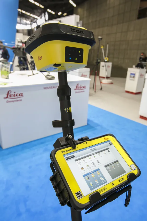
More efficient construction operations should be the benefit of the new technology from Leica Geosystems. The firm is introducing its latest Leica iCON telematics package, which is said to offer increased efficiency for machine control operations on site and remote machinery fleet management. The Leica iCON telematics package is a web-based suite of tools that allows contractors to increase the efficiency of machine control operations on site and manage machinery fleets. This is a key component in iCONnect,

More efficient construction operations should be the benefit of the new technology from 265 Leica Geosystems. The firm is introducing its latest Leica iCON telematics package, which is said to offer increased efficiency for machine control operations on site and remote machinery fleet management.
The Leica iCON telematics package is a web-based suite of tools that allows contractors to increase the efficiency of machine control operations on site and manage machinery fleets. This is a key component in iCONnect, one of the four pieces of the Leica iCON solution, and offers substantial telematics functionalities.
The Leica iCON telematics services include fast and easy data transfer from office to site and to construction machines, remote support for the operators and basic fleet management. The package integrates with the workflow on construction projects and the Leica iCON solutions, simplifying work processes and enabling significant time and cost savings.
Leica iCON telematics currently consists of three modules, View, Sync and Track, which can be accessed through a web-based interface to find key information. Users are also presented with a fleet overview and have overlay project data on Google Maps.
View supports multitasking, meaning users can have several machine panels active simultaneously. The office manager or support personnel can remotely view the operator’s screen, carry out remote diagnostics and provide instant support. This reduces site visits and saves time by remotely checking settings on the machine. Supervisors can increase machine uptime by scheduling operator training with a remote instructor.
Sync allows the latest design data to be transferred to the machine fleet, ensuring the fleet works with up-to-date project files on the machines. Data can be transferred remotely in both directions from the field to the office and back. New firmware can also be uploaded remotely in what reduces machine visits, decreases downtime and simplifies support and maintenance.
Track functionality allows the user to monitor the machine fleet in real time and provide regular activity reports by machine or by project. It optimises day-to-day operations by tracking machines in real time and monitoring equipment utilisation on site.