A new cycle way monitoring system developed by consultant Cowi and laser electronics company Dynatest in Denmark adds a new dimension to monitoring local road networks. It is developed from standard road condition measurements but is specially tailored for the bicycle path and the particular ride conditions needed for cyclists. The need is growing as the bicycle lane becomes increasingly important around the world. In London a number of special bicycle "super highways" have been introduced, marking off bicy
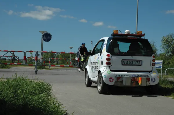
A new cycle way monitoring system developed by consultant Cowi and laser electronics company Dynatest in Denmark adds a new dimension to monitoring local road networks
It is developed from standard road condition measurements but is specially tailored for the bicycle path and the particular ride conditions needed for cyclists.The need is growing as the bicycle lane becomes increasingly important around the world. In London a number of special bicycle "super highways" have been introduced, marking off bicycle priority lanes and route sections from the inner city to the outer suburbs, with an aim of increasing bicycle use 400% by 2015. Denmark has a network of bicycle lanes and is planning its own super-cycle track into Copenhagen with a high quality surfacing, while the hill-less Netherlands is famous for a network of bicycle paths running parallel to most of its roads in towns, and outside too. Scandinavia is bicycle friendly despite its mountains and sport and health-conscious Australia routinely includes bicycle paths as part of major highway schemes, like Melbourne's recently opened EastLink.
But according to Brian Henriksen from
Visual inspections are made but do not really capture the state of the bike paths. "But neither would a standard road laser survey," he said, "because the ride quality for a cyclist is different to that of cars."
A cyclist himself, he became so annoyed at a bad patch on the bicycle way he took to his work, then at
Secondly, new software was needed because it had to give a measurement that reflected cyclists' needs. The International Roughness Index for road asphalt does not work for cycling and so over a period he developed a new algorithm. Using laser scans with longitudinal profiles at 25mm spacing he produced what he called the "bicycle profile index".
One of the major challenges he explains, was to devise software solutions to a problem with the scanners which lose accuracy if the vehicle has to slow below 20km/h, "...which you must often do on a bicycle route," he said. The potential distortions in the signal were however overcome.
It took about a half year to work out a system and to then convince an authority to give it a trial run. The relatively large town of Odense agreed to a first use for its quite extensive 300km network of bike paths. "It worked well and gives a much more consistent result than visual inspection done previously by four different people," he said. The output is fed into a GIS display to show good and bad areas on the network, "...and in fact it can help plot the full extent of a network for authorities that do not have full records of the all the paths they may have," he said.
Since the Odense experiment the car has been used by seven or eight local authorities in Denmark, "...though we have not had any success persuading Copenhagen to do this yet," he commented.
He hopes that the index can be filed as a standard in Danish law, though initial approaches to the Danish Road Authority did not draw any interest. There is interest from elsewhere in Scandinavia and parts of Germany and he thinks US cities like Los Angeles, Boston, New York and others with increasing cycling interest may well be possible users.