Christmas 2016 came early for Bentley's global clients. In fact, they had a hint of what was going to be under their tree come the celebrations in December.
On November 1, at Bentley’s annual global client gathering and awards event Year in Infrastructure Conference in London, the solutions provider announced that OpenRoads Designer CONNECT Edition would be available for early access on December 1. The announcement was welcomed by conference attendees as an important component of the overall OpenRoads CONNECT Edition - successor to Bentley’s industry-leading civil engineering brands InRoads, GEOPAK, MX and PowerCivil (see box on p35).
“OpenRoads CONNECT Edition is the culmination of three decades of Bentley leadership and experience gained from thousands of roadway projects around the world,” explains Bhupinder Singh, chief product officer of
OpenRoads Designer is a comprehensive, multi-discipline 3D modeling application to advance the delivery of roadway projects from conceptual design through construction. It blends traditional engineering workflows for plan, profile and cross sections with 3D parametric modeling to enable the model-centric creation of all design deliverables.
Multidiscipline support
OpenRoads Designer supports all aspects of a detailed roadway design including survey, geotechnical, drainage, subsurface utilities, terrain, road, roadway furniture and more. The incorporation of reality meshes, imagery, point cloud and other geo-coordinated data sources provide continuous context of real-world conditions throughout design and construction lifecycle. OpenRoads Designer completes the convergence of InRoads, GEOPAK, MX, and PowerCivil. However, it adds many powerful innovations.
All detailed design in OpenRoads Designer is driven by functional components. These inherently respond contextually to express appropriate design, annotation and to plan set display behaviours. Design models are expressed in multiple live views, including plan, profile, cross section and 3D. Changes in one view are live and dynamically update all views.
OpenRoads Designer offers multidiscipline support. It integrates support for each discipline with specific user profiles dedicated to each discipline. Users may switch discipline perspectives, for example from road design profile to subsurface utility profile.
Reality modeling
OpenRoads Designer also has reality modeling tools to incorporate and edit all reality modeling data types, including the capability to extract ground-level features from reality meshes and LiDAR as well as to reference point clouds and imagery.
OpenRoads Designer users have at their fingertips comprehensive geotechnical tools that allow them to connect directly to gINT geotechnical databases to incorporate subsurface terrain details into their models for improving grading and piling. Subsurface terrains can be generated or modeled based on borehole materials and projected in road and drainage profiles, sections and plans.
Subsurface utilities work has been enhanced. Users can select from a large catalogue of functional components for utility and drainage to model underground drainage and utility networks. Drainage models, moreover, can be optimised for water flow using integrated water analysis tools, with results available in data tables or visually in a profile view.
OpenRoads Designer offers an expanded set of deliverables, from traditional plan sets and animations to digital construction models for automated machine control and field positioning systems including for excavation, grading, piling, and paving.
Enlivened visualisation
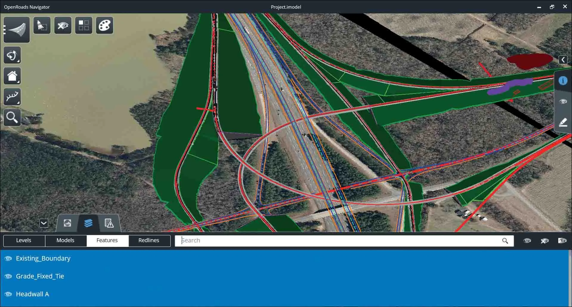
OpenRoads Designer provides direct integration to Bentley LumenRT for producing cinematic visualisation. Projects are enhanced with added vegetation to reflect nature and climate. Traffic simulation with VI SSIM ensures that the work comes to life.Designs created in OpenRoads Designer benefit from BIM Review through OpenRoads Navigator, in the office, in the field and at the site. OpenRoads Navigator enables not only visualisation and review of 3D designs, but also status visibility to allow dispersed teams to progress approvals and resolve issues.
Onwards to Singapore, October 2017
Bentley’s next Year in Infrastructure Conference is at the Sands Expo and Convention Centre, Marina Bay Sands, Singapore, from October 10-12, 2017.
Structural design of the Marina Bay Sands Resort was done by consulting engineer
The 2,561-room Marina Bay Sands Resort includes three 55-storey towers. It has nearly 121,000m² of meeting space, a 300-store mall, a museum, two large theatres, many restaurants and the world’s largest atrium casino. It is topped by a 341m-long Sky Park with a capacity for 3,900 people and a 45.5m infinity swimming pool - the world’s largest public cantilevered platform.
Bentley Systems has contributed to the advancement of infrastructure in South East Asia, most recently - and notably - with Singapore’s Mass Rapid Transit. The public transit system selected Bentley’s Optram software to model, analyse and provide decision support for the maintenance of the MRT track assets.
Also in Singapore, the Land Authority has used Bentley software to create and maintain a high-resolution 3D model of the entire country under its Smart Nation initiative. This 3D model will cover an area of more than 700km² and include maps, terrain, surface, buildings and roads. This data will be shared by government agencies to support operations, planning and risk management.
• Bentley’s Year in Infrastructure Conference will return to London for 2018.
OpenRoads’ immersive 3D modeling
OpenRoads CONNECT Edition is one of the latest products from Bentley. The provider’s solutions encompass MicroStation applications for information modeling, ProjectWise collaboration services to deliver integrated projects and AssetWise operations services to achieve intelligent infrastructure – complemented by worldwide professional services and comprehensive managed services.
One of the results of this investment is the OpenRoads CONNECT Edition that integrates OpenRoads ConceptStation, OpenRoads Designer and OpenRoads Navigator. It ensures a comprehensive modeling environment for the delivery of roadway projects, streamlining and automating workflows across all disciplines to progress designs from conception to detailed design and through construction.
OpenRoads’ immersive 3D modeling environment also leverages 3D reality meshes for continuously surveyed context of site conditions throughout design and construction.
Project delivery teams, owner-operators and construction firms benefit from OpenRoads’ connected data environment—enabled through ProjectWise—to access, store, share and manage all project data and models, from concept through construction, for information mobility across disciplines and in the field. OpenRoads takes advantage of a connected data environment’s Component Center to enable rapid and consistent modeling for every project, owner and contractor.
The company, founded in 1984, operates in more than 50 countries and has in excess of US$600 million in annual revenue. Bentley is highly committed to research, having invested more than $1 billion in R&D, including strategic acquisitions, since 2009.


