Pont-de-Veyle is a picturesque village of around 1,600 people in France’s eastern Rhones-Alps region. Being in a tourist area and close to major towns and cities meant that traffic – around 9,000 vehicles a day through its small streets – was becoming a concern
The village sits about 30km from the larger town of Bourg-en-Bresse, towards the Swiss border. It also lies around 60km from the city of Lyon, all in the Department of Ain. The regional administrative authority Ain created the Conseil Départementa
Pont-de-Veyle is a picturesque village of around 1,600 people in France’s eastern Rhones-Alps region. Being in a tourist area and close to major towns and cities meant that traffic – around 9,000 vehicles a day through its small streets – was becoming a concern
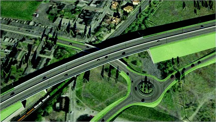
The village sits about 30km from the larger town of Bourg-en-Bresse, towards the Swiss border. It also lies around 60km from the city of Lyon, all in the Department of Ain. The regional administrative authority Ain created the Conseil Départemental de l’Ain, a roadworks organisation, to complete the region’s motorway network. One of the Conseil’s latest projects was to design a bypass for Pont-de-Veyle to reduce the number of vehicles that passed through it daily from the 9,000 to 4,000. In addition, the design had to maintain the economic viability of the town and alleviate its flooding issues.
The Conseil has frequently used6197 Bentley’s 3D modeling software including MicroStation, MXROAD and PowerCivil for France. “Bentley software has become indispensable to our projects in view of today’s much tighter budgets and completion times,” said Yves Genevois, planner for the Conseil and who has been advising cities for more than 30 years,
“Previously, we had to use an outside design office to produce our digital mockups, which cost us about €20,000 per mockup for 5-6km of road. Today, we are fully autonomous with our Bentley software. We manage our own projects from the initial survey through to solution delivery.”
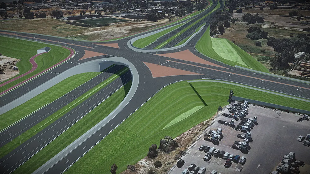
The project team studied the proposed roadway geometry and environmental constraints for the Pont-de-Veyle bypass. They used Bentley products to manage the digital production chain end-to-end and collaborate with surveyors, hydraulic engineers, town planners, environmental technicians and – importantly - elected officials.
The team faced many challenges - obtaining information from all stakeholders, incorporating LiDAR data, interacting with various participants, designing the road, positioning it in its environment and redesigning where necessary. The team also needed to present a virtual 3D mockup with as many details, animations and videos as possible to gain project approval from a wide audience.
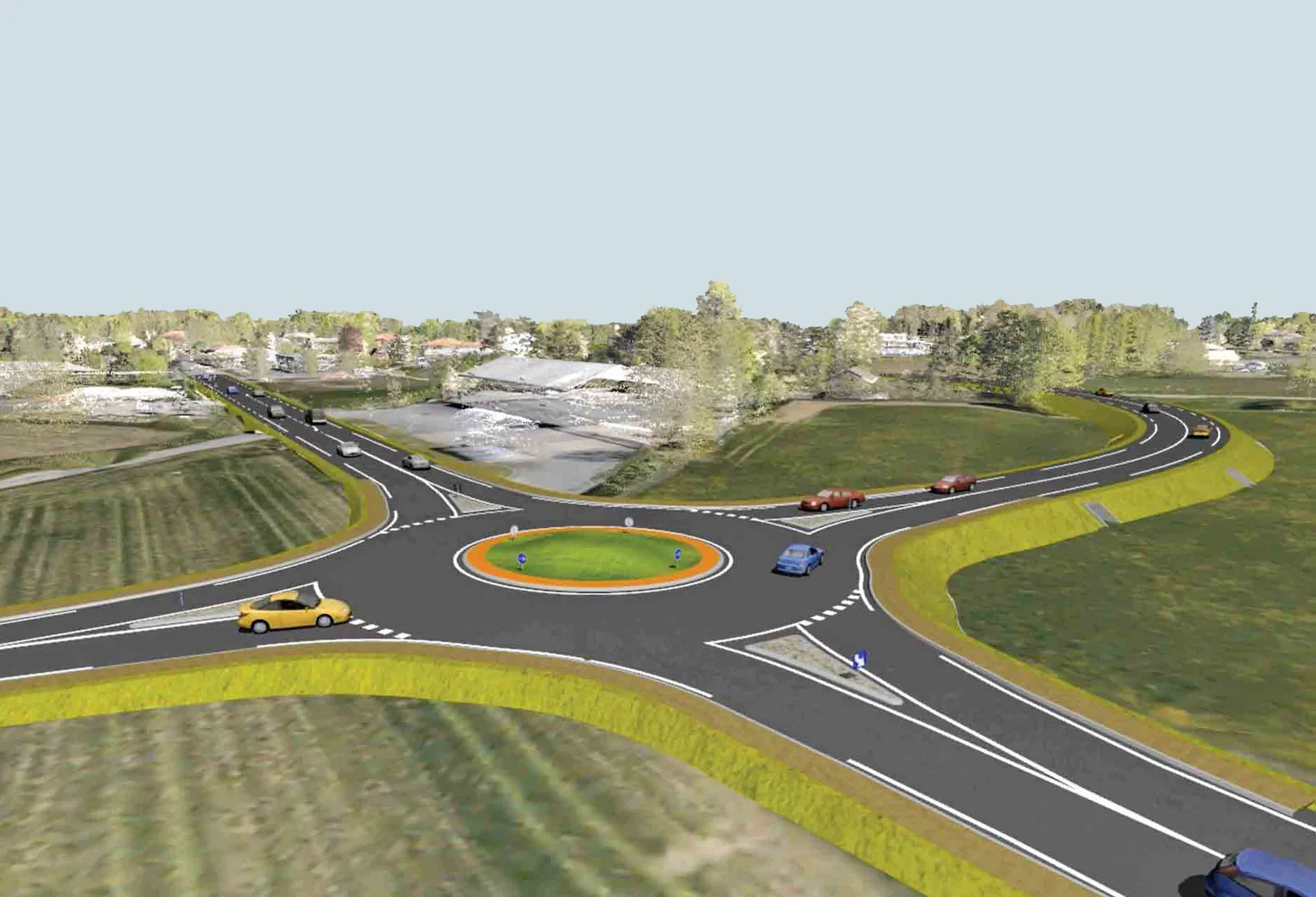
For this project, the team opted for the use of high-definition colour point clouds: 172 million points for 500 hectares of terrain. This process provided an almost photo-realistic rendering that was more detailed than a conventional virtual mockup. It was also more manageable because it could be infinitely and dynamically modified.
Using MXROAD and PowerCivil for France, the dynamic links between the project’s different objects allowed operators to make changes quickly without losing information or converting data. The software also integrated the various formats, which facilitated data exchange with other participants.
Genevois says that the innovative aspect of this project was integration of the 3D environment in the form of a high-resolution coloured point cloud, which was a new approach for a motorway project. The team produced a virtual mockup that was nearly an exact replica of the environment.
One of the main concerns on the project was the size of the LiDAR point-cloud file that was imported into Bentley Descartes and Bentley Pointools. Using both software applications, the team was able to not only import the file, but also manipulate, modify and export the file with ease.
Using Bentley Pointools, the design team easily prepared the point clouds for use in MXROAD. Bentley Descartes increased the point-cloud handling and processing capabilities in MXROAD and PowerCivil for France, enhancing the work of the design teams. The resulting consistency and ease of collaboration were clear time savers.
“This was a new approach for us,” says Genevois. “The method was enormously helpful from all points of view, particularly in terms of speed of design, reliability of modifications and cost optimisation. In my mind, the Pont-de-Veyle project was a real turning point for us. It changed our ideas about the profession completely, bringing them perfectly in line with the latest technological developments.”
Bringing digital visualisations in-house also saved an estimated €20,000 for every 5-6km of road.
The road department presented not just the bypass project, but all the hydraulics aspects as well, to account for flooding risks, through visualisations of rising water levels and various means to evacuate the floodwater.
The village sits about 30km from the larger town of Bourg-en-Bresse, towards the Swiss border. It also lies around 60km from the city of Lyon, all in the Department of Ain. The regional administrative authority Ain created the Conseil Départemental de l’Ain, a roadworks organisation, to complete the region’s motorway network. One of the Conseil’s latest projects was to design a bypass for Pont-de-Veyle to reduce the number of vehicles that passed through it daily from the 9,000 to 4,000. In addition, the design had to maintain the economic viability of the town and alleviate its flooding issues.
The Conseil has frequently used
“Previously, we had to use an outside design office to produce our digital mockups, which cost us about €20,000 per mockup for 5-6km of road. Today, we are fully autonomous with our Bentley software. We manage our own projects from the initial survey through to solution delivery.”
The project team studied the proposed roadway geometry and environmental constraints for the Pont-de-Veyle bypass. They used Bentley products to manage the digital production chain end-to-end and collaborate with surveyors, hydraulic engineers, town planners, environmental technicians and – importantly - elected officials.
The team faced many challenges - obtaining information from all stakeholders, incorporating LiDAR data, interacting with various participants, designing the road, positioning it in its environment and redesigning where necessary. The team also needed to present a virtual 3D mockup with as many details, animations and videos as possible to gain project approval from a wide audience.
For this project, the team opted for the use of high-definition colour point clouds: 172 million points for 500 hectares of terrain. This process provided an almost photo-realistic rendering that was more detailed than a conventional virtual mockup. It was also more manageable because it could be infinitely and dynamically modified.
Using MXROAD and PowerCivil for France, the dynamic links between the project’s different objects allowed operators to make changes quickly without losing information or converting data. The software also integrated the various formats, which facilitated data exchange with other participants.
Genevois says that the innovative aspect of this project was integration of the 3D environment in the form of a high-resolution coloured point cloud, which was a new approach for a motorway project. The team produced a virtual mockup that was nearly an exact replica of the environment.
One of the main concerns on the project was the size of the LiDAR point-cloud file that was imported into Bentley Descartes and Bentley Pointools. Using both software applications, the team was able to not only import the file, but also manipulate, modify and export the file with ease.
Using Bentley Pointools, the design team easily prepared the point clouds for use in MXROAD. Bentley Descartes increased the point-cloud handling and processing capabilities in MXROAD and PowerCivil for France, enhancing the work of the design teams. The resulting consistency and ease of collaboration were clear time savers.
“This was a new approach for us,” says Genevois. “The method was enormously helpful from all points of view, particularly in terms of speed of design, reliability of modifications and cost optimisation. In my mind, the Pont-de-Veyle project was a real turning point for us. It changed our ideas about the profession completely, bringing them perfectly in line with the latest technological developments.”
Bringing digital visualisations in-house also saved an estimated €20,000 for every 5-6km of road.
The road department presented not just the bypass project, but all the hydraulics aspects as well, to account for flooding risks, through visualisations of rising water levels and various means to evacuate the floodwater.