Accurate surveys

Leica Geosystems says that its new Viva TS12 performance robotic package offers a comprehensive package of surveying solutions.
February 21, 2012 Read time: 1 min
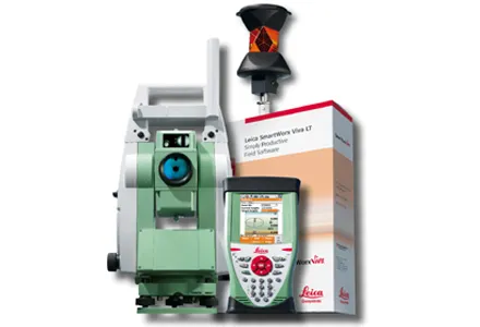
265 Leica Geosystems says that its new Viva TS12 performance robotic package offers a comprehensive package of surveying solutions. High accuracy surveying can be achieved using this cost-effective system, according to the firm. The package comprises the Leica Viva TS12 Total Station, the Viva CS10 Controller and the easy-to-use SmartWorx Viva Onboard Software. The Viva TS12 can be used to find, lock and measure points to prisms with accuracy. The PowerSearch sensor is said to locate any prism type within seconds, regardless of location. The Viva CS10 is said to be ergonomic in design and light in weight, allowing long range, secure and fast wireless connectivity to the Viva TS12. Meanwhile the SmartWorx Viva LT is designed using clear graphics, non-technical terminology and simplified workflows and is said to allow users to complete surveying tasks within a minimum of time.
For more information on companies in this article

Related Content

  • Mobile mapping innovation
    June 1, 2022
    There are millions of kilometres of roads and features that need to be mapped in today’s world. We see a strong vision and application for the future, therefore Leica Geosystems, part of Hexagon, recently announced the introduction of the reality capture mobile mapping system Leica Pegasus TRK, introducing artificial intelligence, autonomous workflows and intuitive interfaces. This technology goes beyond the capabilities of what’s already been done, making it the perfect companion for today’s mobile mapping requirements.
  • Software and control innovations introduced
    August 28, 2023
    New developments in construction machine control systems and construction software are helping to change the face of the industry
  • Keeping in touch
    February 6, 2012
    Leica Geosystems says that its latest package offers an efficient solution for monitoring communications. The updated GeoMoS v5.1 monitoring software features M-Com, which can integrate total stations, GNSS receivers and antennae, geotechnical sensors, software, and IT communication infrastructure. In addition the revised Leica GeoMoS v5.1 also supports the latest Microsoft Windows 7 operating system. The firm says that this package is easy to install and use, while increasing the mobility of periodic or sh
  • Digital solutions for accurate road construction
    November 19, 2021
    Construction firms are now delivering roads that are more durable and feature better surface quality due to the use of digital measurement solutions. These technologies help to transfer target values into precise actual values on the ground