Accurate surveys

Leica Geosystems says that its new Viva TS12 performance robotic package offers a comprehensive package of surveying solutions.
February 21, 2012 Read time: 1 min
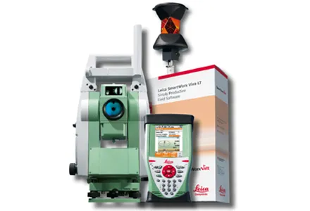
265 Leica Geosystems says that its new Viva TS12 performance robotic package offers a comprehensive package of surveying solutions. High accuracy surveying can be achieved using this cost-effective system, according to the firm. The package comprises the Leica Viva TS12 Total Station, the Viva CS10 Controller and the easy-to-use SmartWorx Viva Onboard Software. The Viva TS12 can be used to find, lock and measure points to prisms with accuracy. The PowerSearch sensor is said to locate any prism type within seconds, regardless of location. The Viva CS10 is said to be ergonomic in design and light in weight, allowing long range, secure and fast wireless connectivity to the Viva TS12. Meanwhile the SmartWorx Viva LT is designed using clear graphics, non-technical terminology and simplified workflows and is said to allow users to complete surveying tasks within a minimum of time.
For more information on companies in this article

Related Content

  • Developments in site survey solutions
    February 9, 2012
    Trimble is widening its portfolio of Connected Site survey solutions for the field and office. These upgraded tools allow surveyors to collect, share and deliver data faster to improve accuracy, efficiency and productivity.
  • Sophisticated surveying tool from Topcon
    September 4, 2019
    Topcon Postioning is now offering a sophisticated surveying tool in the shape of an auto-collimating total station for surveying professionals looking for a motorised solution. The firm says that this rugged waterproof total station benefits from the latest TSshield technology for advanced security and maintenance. The system can also be upgraded to Autotracking when the customer is ready to advance further to robotic applications. The GT-503M can be used for Tunnel Guidance and Periodic Monitoring applicat
  • Accurate deformation monitoring from Leica Geosystems
    March 7, 2017
    Leica Geosystems is now offering a sophisticated tool that allows engineers to measure deformation accurately. The Leica GeoMoS Now! Survey Edition is a service for monitoring and managing 3D deformation of points of potentially unstable areas for surveying projects. It has a streamlined workflow and can deliver monitoring reports of man-made structures or natural dangers to smart devices. Surveyors can use this to upload coordinates, process and visualise deformations, allowing other users to access result
  • ScanStation C10: sophisticated
    March 1, 2012
    High-speed, versatile laser scanning can now be achieved using the latest technology from Leica Geosystems. The firm's sophisticated ScanStation C10 package features a new high-definition surveying (HDS) scanner that is said to increase surveying productivity and accuracy for both routine surveys and large, complex projects.