Accurate surveys

Leica Geosystems says that its new Viva TS12 performance robotic package offers a comprehensive package of surveying solutions.
February 21, 2012 Read time: 1 min
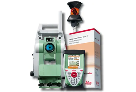
265 Leica Geosystems says that its new Viva TS12 performance robotic package offers a comprehensive package of surveying solutions. High accuracy surveying can be achieved using this cost-effective system, according to the firm. The package comprises the Leica Viva TS12 Total Station, the Viva CS10 Controller and the easy-to-use SmartWorx Viva Onboard Software. The Viva TS12 can be used to find, lock and measure points to prisms with accuracy. The PowerSearch sensor is said to locate any prism type within seconds, regardless of location. The Viva CS10 is said to be ergonomic in design and light in weight, allowing long range, secure and fast wireless connectivity to the Viva TS12. Meanwhile the SmartWorx Viva LT is designed using clear graphics, non-technical terminology and simplified workflows and is said to allow users to complete surveying tasks within a minimum of time.
For more information on companies in this article

Related Content

  • Leica’s new Digicat xf-Series cable locators and transmitters
    January 6, 2017
    Leica Geosystems has launched the latest editions to the Digisystem product range: the Leica Digicat xf-Series. With Leica Geosystems’ new xf-Series cable locators and transmitters, users are said to be able to accurately detect and trace utilities faster and over a greater distance. The Leica Digicat xf-Series is said by the Swiss firm to have been specifically designed with long distance tracing in mind. The ability to trace transmitter frequencies of 512Hz and 640Hz provides users with a greater tracing r
  • Leica’s new Digicat xf-Series cable locators and transmitters
    January 30, 2013
    Leica Geosystems has launched the latest editions to the Digisystem product range: the Leica Digicat xf-Series. With Leica Geosystems’ new xf-Series cable locators and transmitters, users are said to be able to accurately detect and trace utilities faster and over a greater distance. The Leica Digicat xf-Series is said by the Swiss firm to have been specifically designed with long distance tracing in mind. The ability to trace transmitter frequencies of 512Hz and 640Hz provides users with a greater tracing r
  • Monitoring software update from Trimble
    November 15, 2019
    Trimble is offering an updated version of its real-time monitoring software, the 4D Control package. This Version 5.0 upgrade offers new features that allow users to streamline real-time structural monitoring system deployment as well as simplify the connection to geotechnical sensors. Trimble 4D Control software allows project stakeholders to monitor critical infrastructure such as dams and bridges along with buildings surrounding construction sites and tunnels.
  • Positioning tools continue to improve
    July 16, 2012
    Topcon says that its new IP-S2 package combines GNNS positioning capabilities with inertial sensors, while the firm also has a solution for customers wanting to mix and match receiver components. The IP-S2 is a vehicle-mounted, mobile 3D tool that offers precision mapping and surveying capabilities. The package collects data using 3D laser scanners, LIDAR, and/or cameras, and this is then integrated, time-stamped and geo-referenced. The customer can use this assembled data to combine LIDAR point cloud and d