Situated on India’s northern frontier, the state of Jammu and Kashmir is world-renowned for its aesthetic vistas and captivating landscapes. The arterial roads connecting the city of Jammu to that of Srinagar is a challenge to maintain, being constantly exposed to harsh weather and overburdened with vehicular movement. Leica Geosystems has been involved in the Chenani-Nashri tunnel project, India’s longest road tunnel and which will be part of an alternate route in the region
Situated on India’s northern frontier, the state of Jammu and Kashmir is world-renowned for its aesthetic vistas and captivating landscapes. The arterial roads connecting the city of Jammu to that of Srinagar is a challenge to maintain, being constantly exposed to harsh weather and overburdened with vehicular movement. Leica Geosystems has been involved in the Chenani-Nashri tunnel project, India’s longest road tunnel and which will be part of an alternate route in the region
This project is part of a US$723 million initiative by the National Highways Authority of India (NHAI) connecting Jammu to Srinagar. Spanning 9km, this prestigious venture will shorten the travel distance from Chenani to Nashri by 31km and reducing travel time by two hours.
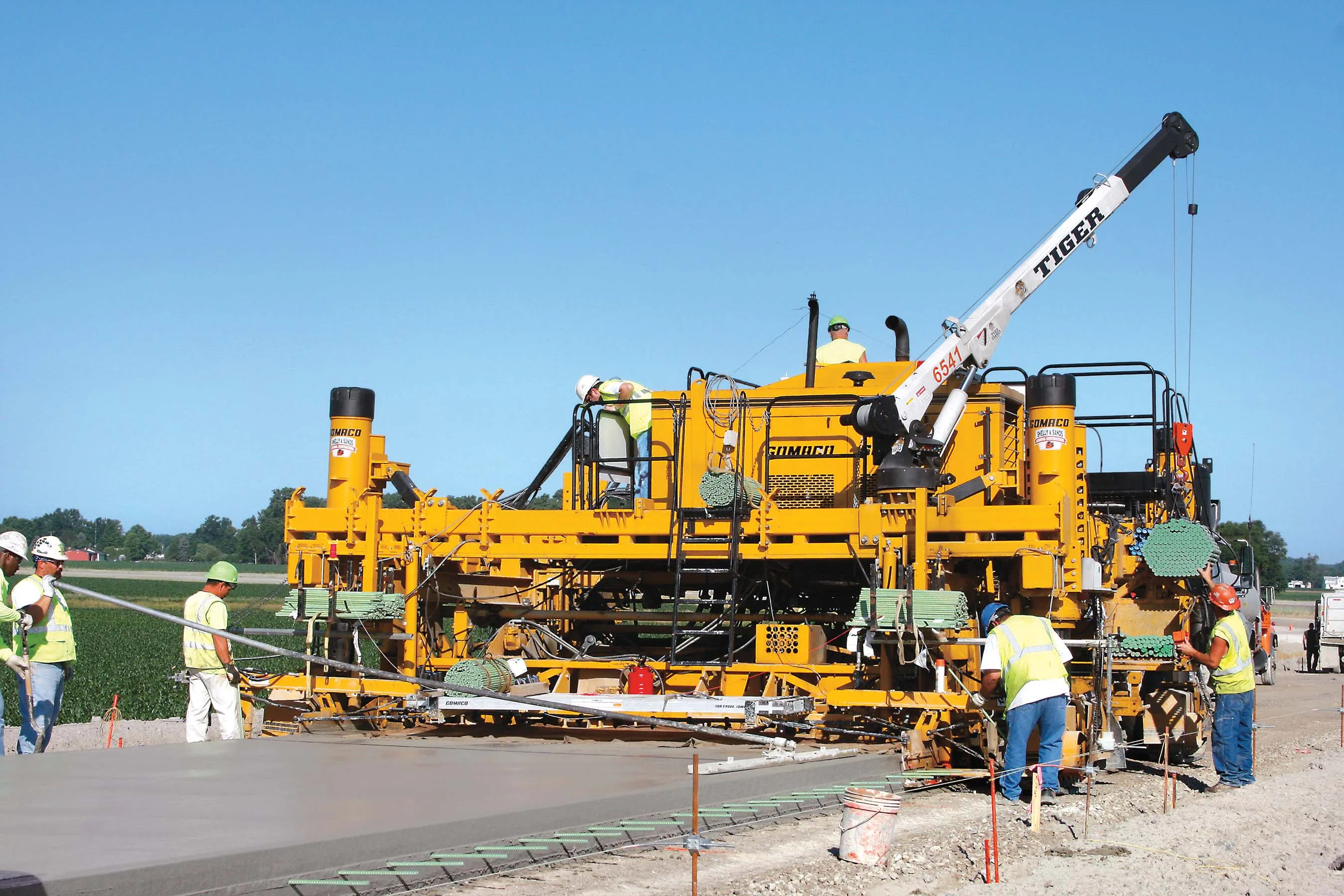
The project, undertaken partly by New India Structures (NIS), has special significance as it is the first of its kind to adopt 3D paving technology for concrete paving operations in India. When completed, the two-line, bi-directional traffic tunnel will be an all-weather alternative road that will offer safe and uninterrupted passage to travellers throughout the year.
Conventional methodology for paving dictates setting up of stringlines. This procedure has inherent flaws that handicap the timeline of a project. Physical strings occupy more space, halt vehicular movement and pose a serious safety hazard for onsite personnel.
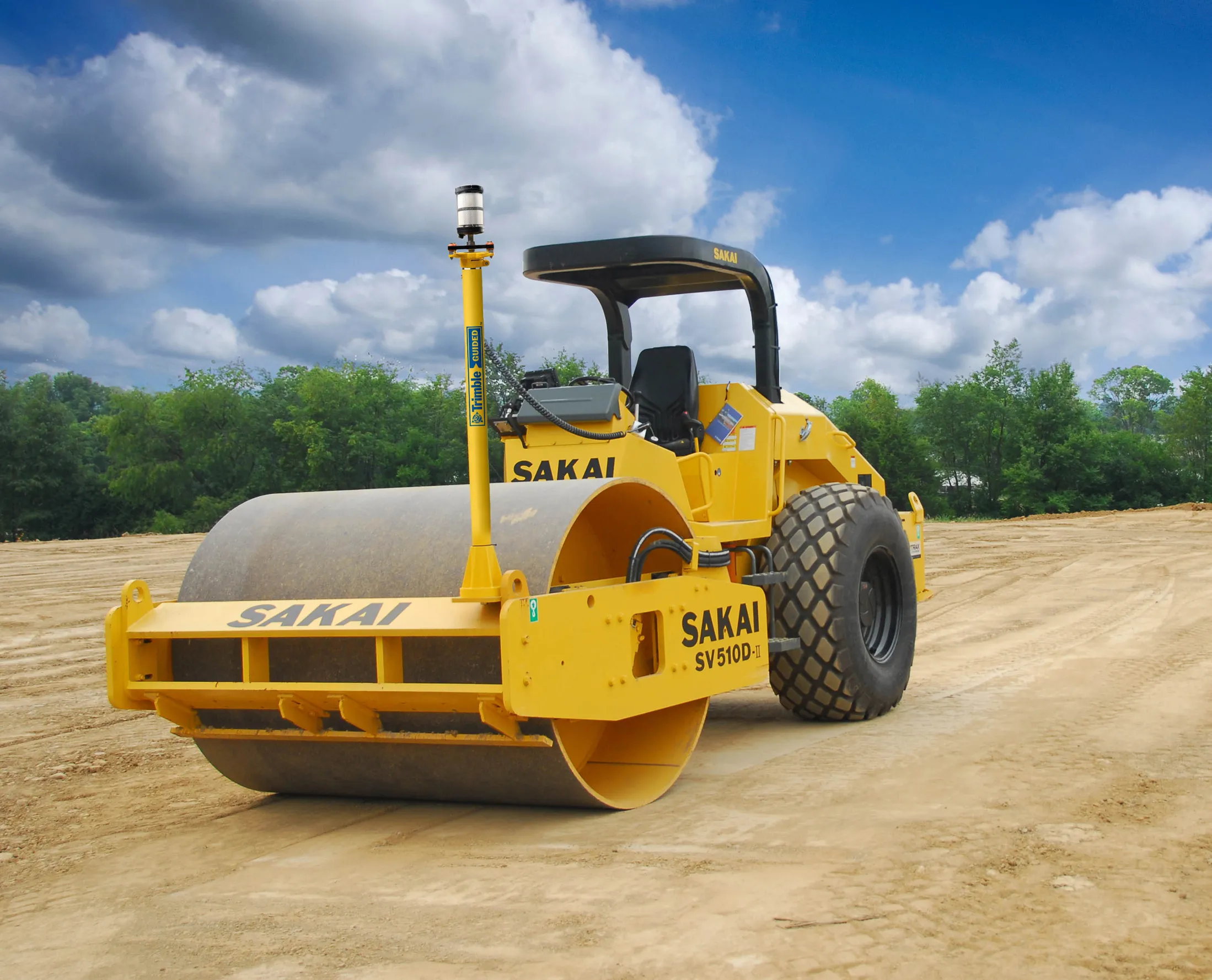
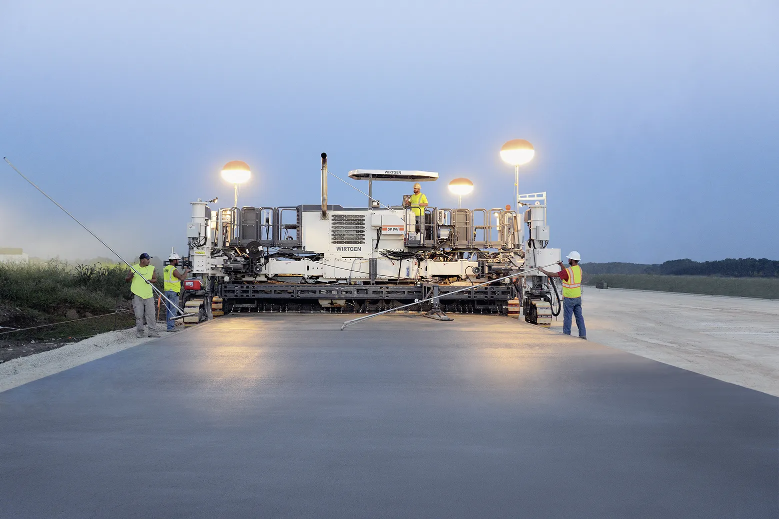
Sidhu envisaged that265 Leica Geosystems’ automated 3D paving technology could overcome these handicaps and enable his company to deliver a product that meets high standards under such challenging conditions. The implemented 3D stringless paving solution, PaveSmart 3D, made it possible to operate inside the restricted confines of the tunnel. No stringlines means trucks can deposit concrete and exit the site faster.
"The movement of the tracks is 3D guided, which makes creating curves very easy. This is quite difficult when working with stringlines," explains Santosh Navele, NIS paver operator. The system takes care of all contingencies leaving just one task - to ensure continuous supply of concrete.
"Adopting Leica Geosystems solutions enabled the execution of multiple activities simultaneously. Paving the road, lining to tunnel walls, and installing electrical conduits were done together. Additionally, the amount of labour employed and fuel costs could be reduced," says Sidhu.
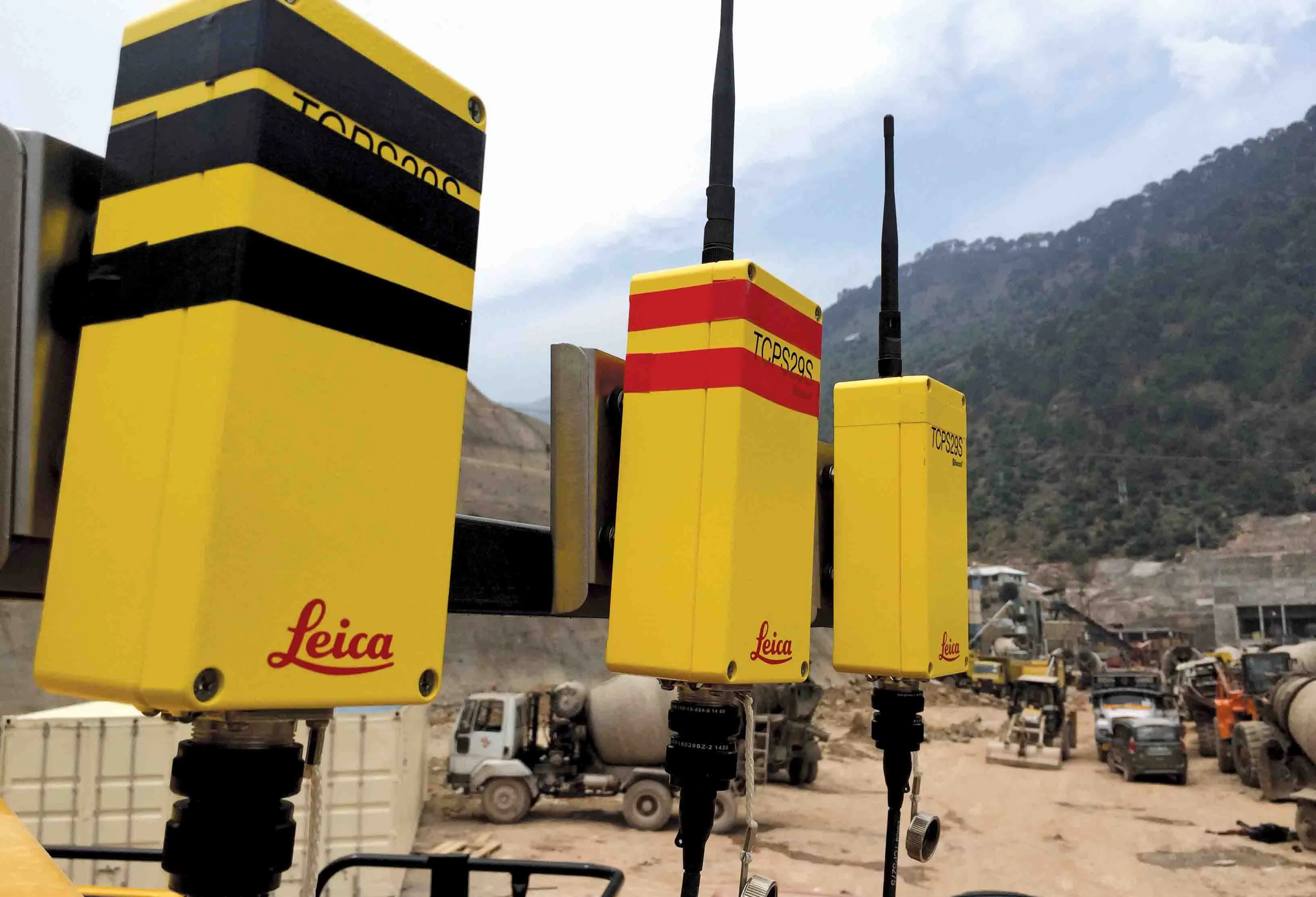
On the day of paving, the survey team set up the Leica Viva TS15 robotic total station, track it to the 360 prism mounted on the paver and, with the help of Pavesmart 3D, pave without interruptions.
The PaveSmart 3D system uses the survey data to control the steering tracks and movement of the hydraulics of the paver to ensure that the finished surface is always as per the data. The probability of error or deviation from design data is eliminated by setting tolerances within the machine computer. When these limits are exceeded, the hydraulics and steering get locked.
"Resuming work the next day is convenient and faster. The mold of the paver is aligned to the previous day’s end point to continue paving. The 3D control system eliminates cumbersome work and enables us to work faster without compromising quality," says Satyaveer Singh, NIS surveyor at site.
Jürgen Seemann, programme manager roads for Leica Geosystems, on PaveSmart 3D
Q1. How would you describe the game-changing idea behind PaveSmart 3D?
A. When Leica Geosystems’ pioneering 3D paving control system was launched a decade ago, it truly revolutionised the way paving was done. Completely removing stringlines, users’ productivity, quality and safety are significantly increased.
Through direct control with 3D design, Leica PaveSmart 3D is being used around the world in hundreds of high-profile infrastructure projects, producing precision results at lower costs. Leica PaveSmart 3D monitors, with the use of various positioning sensors (total stations or GNSS, depending on required accuracy and setting), the position of the machine versus the 3D project data. In case of a deviation, this data is instantly sent back to the machine control system, which sends a signal to the hydraulics for correction of slope or elevation.
In case of a malfunction or too large a deviation from the 3D design project, Leica PaveSmart 3D sends a stop signal to the machine to avoid incorrect operation.
For slipform operation, PaveSmart 3D controls elevation, slope and steering. For asphalt paving PaveSmart 3D is able to monitor elevation, slope, working width and steering, but this functionality depends very much on the OEM. In case of milling operation, steering control is, for safety reasons, prohibited. PaveSmart 3D is directly connected via a 3D interface with the OEM CanBus.
Q2. When and how did your organisation come up with the idea?
A. Leica Geosystems has almost 200 years of expertise in measurement technology. We began developing our Machine Control focus around 1995. From our entrance into the heavy construction sector, we immediately noticed the dangers that employees working on paving projects from highways to airports faced, and the inefficiencies. We set about to change this in the industry with our machine control and guidance systems. In the 1990s as high-speed trains were coming onto the scene, we began to receive requests for more precise and smoother pavement. In 1996 we introduced a revolutionary positioning system for slipform paving and the following year we had our first successful test on a high-speed railway project in Germany.
By 1999, the first version of our machine control guidance systems was released after extensive research and development and testing. Before Leica Geosystems releases a PaveSmart 3D System for a specific machine model, we run intensive integration tests and strictly follow test plans to ensure the highest quality. PaveSmart 3D is successfully tested and approved on all major asphalt and concrete pavers and milling machine manufacturers in the world.
PaveSmart 3D continues to evolve through our worldwide user community partnership. We’ve added abilities to calculate and compare the design model’s grade and position directly in the cab of the paver, make immediate steer and elevation corrections and precisely regulate the hydraulics for the highest quality paving and milling results.
Q3. In which countries is it now operating and on what types of projects?
A. Leica PaveSmart 3D operates globally with a focus in Europe, North America, Russia and Asia Pacific. We are seeing increasing demand, however, in developing countries such as China and India where we have successfully installed the first 3D paving systems. This technology is used in a wide array of projects:
• road construction - asphalt paving
• road maintenance - milling
• concrete roads
• pavements in tunnels
• kerb and gutter operations
• airport runway paving
• canals
Q4. What are some real-world examples of savings using PaveSmart 3D?
A. From supporting the construction of the first airport on an island nation to providing cleaner air quality with the introduction of the first public transportation networks in desert cities, Leica PaveSmart 3D offers several benefits to not only users but also communities in which the technology is employed. While in use on the extension of a tramline in Nottingham, UK, project managers claimed 30-40% time savings, also significantly decreasing the time workers were on site facing risks. For a highway paving project in the US state of Iowa, project managers reached 70-80% of smoothness incentives using Leica PaveSmart 3D.
Finally, one of the first asphalt paving application projects in Morocco to use the technology realised a €15,000 cost savings per day when deviations were improved by 12mm.
This project is part of a US$723 million initiative by the National Highways Authority of India (NHAI) connecting Jammu to Srinagar. Spanning 9km, this prestigious venture will shorten the travel distance from Chenani to Nashri by 31km and reducing travel time by two hours.
The project, undertaken partly by New India Structures (NIS), has special significance as it is the first of its kind to adopt 3D paving technology for concrete paving operations in India. When completed, the two-line, bi-directional traffic tunnel will be an all-weather alternative road that will offer safe and uninterrupted passage to travellers throughout the year.
Addressing the challenges
NIS, under the stewardship of Mr. Parminder Singh Sidhu, began the paving of the tunnel road in March 2016. This tunnel road will include the construction of a 9km highway, a single-span 50m bridge at the north portal of the tunnel and a 40m single-span approach bridge at the south portal.Conventional methodology for paving dictates setting up of stringlines. This procedure has inherent flaws that handicap the timeline of a project. Physical strings occupy more space, halt vehicular movement and pose a serious safety hazard for onsite personnel.
Sidhu envisaged that
Delivering cost-efficient surfaces
Unlike the conventional work detail where strings are setup on a day-to-day basis, the 3D system takes data only once."The movement of the tracks is 3D guided, which makes creating curves very easy. This is quite difficult when working with stringlines," explains Santosh Navele, NIS paver operator. The system takes care of all contingencies leaving just one task - to ensure continuous supply of concrete.
"Adopting Leica Geosystems solutions enabled the execution of multiple activities simultaneously. Paving the road, lining to tunnel walls, and installing electrical conduits were done together. Additionally, the amount of labour employed and fuel costs could be reduced," says Sidhu.
On the day of paving, the survey team set up the Leica Viva TS15 robotic total station, track it to the 360 prism mounted on the paver and, with the help of Pavesmart 3D, pave without interruptions.
The PaveSmart 3D system uses the survey data to control the steering tracks and movement of the hydraulics of the paver to ensure that the finished surface is always as per the data. The probability of error or deviation from design data is eliminated by setting tolerances within the machine computer. When these limits are exceeded, the hydraulics and steering get locked.
"Resuming work the next day is convenient and faster. The mold of the paver is aligned to the previous day’s end point to continue paving. The 3D control system eliminates cumbersome work and enables us to work faster without compromising quality," says Satyaveer Singh, NIS surveyor at site.
Bright future for the road industry
The tunnel road, part of a wider initiative, is scheduled to open for the public by early 2017. "Our government wants 100,000km of highway to be operational by 2022. To achieve such a volume of work with efficiency and uniformity, automation is necessary. 3D paver automation solutions delivered by Leica Geosystems resulted in better quality, reduced costs and timing, and transparency. This made targets much easier to meet," says Sidhu. Research institutes in India, such as the Central Road Research Institute, are aiming for durable, safe and high-quality road solutions. As witnessed by the Chenani-Nashri tunnel project, NIS opened the way in India for more construction companies to benefit from the efficiency and accuracy delivered by adopting 3D paving technology.Jürgen Seemann, programme manager roads for Leica Geosystems, on PaveSmart 3D
Q1. How would you describe the game-changing idea behind PaveSmart 3D?
A. When Leica Geosystems’ pioneering 3D paving control system was launched a decade ago, it truly revolutionised the way paving was done. Completely removing stringlines, users’ productivity, quality and safety are significantly increased.
Through direct control with 3D design, Leica PaveSmart 3D is being used around the world in hundreds of high-profile infrastructure projects, producing precision results at lower costs. Leica PaveSmart 3D monitors, with the use of various positioning sensors (total stations or GNSS, depending on required accuracy and setting), the position of the machine versus the 3D project data. In case of a deviation, this data is instantly sent back to the machine control system, which sends a signal to the hydraulics for correction of slope or elevation.
In case of a malfunction or too large a deviation from the 3D design project, Leica PaveSmart 3D sends a stop signal to the machine to avoid incorrect operation.
For slipform operation, PaveSmart 3D controls elevation, slope and steering. For asphalt paving PaveSmart 3D is able to monitor elevation, slope, working width and steering, but this functionality depends very much on the OEM. In case of milling operation, steering control is, for safety reasons, prohibited. PaveSmart 3D is directly connected via a 3D interface with the OEM CanBus.
Q2. When and how did your organisation come up with the idea?
A. Leica Geosystems has almost 200 years of expertise in measurement technology. We began developing our Machine Control focus around 1995. From our entrance into the heavy construction sector, we immediately noticed the dangers that employees working on paving projects from highways to airports faced, and the inefficiencies. We set about to change this in the industry with our machine control and guidance systems. In the 1990s as high-speed trains were coming onto the scene, we began to receive requests for more precise and smoother pavement. In 1996 we introduced a revolutionary positioning system for slipform paving and the following year we had our first successful test on a high-speed railway project in Germany.
By 1999, the first version of our machine control guidance systems was released after extensive research and development and testing. Before Leica Geosystems releases a PaveSmart 3D System for a specific machine model, we run intensive integration tests and strictly follow test plans to ensure the highest quality. PaveSmart 3D is successfully tested and approved on all major asphalt and concrete pavers and milling machine manufacturers in the world.
PaveSmart 3D continues to evolve through our worldwide user community partnership. We’ve added abilities to calculate and compare the design model’s grade and position directly in the cab of the paver, make immediate steer and elevation corrections and precisely regulate the hydraulics for the highest quality paving and milling results.
Q3. In which countries is it now operating and on what types of projects?
A. Leica PaveSmart 3D operates globally with a focus in Europe, North America, Russia and Asia Pacific. We are seeing increasing demand, however, in developing countries such as China and India where we have successfully installed the first 3D paving systems. This technology is used in a wide array of projects:
• road construction - asphalt paving
• road maintenance - milling
• concrete roads
• pavements in tunnels
• kerb and gutter operations
• airport runway paving
• canals
Q4. What are some real-world examples of savings using PaveSmart 3D?
A. From supporting the construction of the first airport on an island nation to providing cleaner air quality with the introduction of the first public transportation networks in desert cities, Leica PaveSmart 3D offers several benefits to not only users but also communities in which the technology is employed. While in use on the extension of a tramline in Nottingham, UK, project managers claimed 30-40% time savings, also significantly decreasing the time workers were on site facing risks. For a highway paving project in the US state of Iowa, project managers reached 70-80% of smoothness incentives using Leica PaveSmart 3D.
Finally, one of the first asphalt paving application projects in Morocco to use the technology realised a €15,000 cost savings per day when deviations were improved by 12mm.