Leica Geosystems has released a cloud solution to integrate, manage and analyse surveying and control workflows for heavy construction projects: ConX will increase efficiency and reduce downtime, the company says
Putting Lima, Peru on the map as a major hub in South America via a $2 billion airport rebuild was serious business. This 270,000 square meter challenge at Jorge Chávez International would require 7,000 collaborators to work from the same page — avoiding errors and rework that could jeopardise their timeline and budget.
This is the third topic of the World Highways Roundtable series of discussions. We asked three leading experts on machine control technology - from Leica Geosystems, Topcon and Trimble - to tell us how their solutions are helping the construction industry deal with labour shortages, an ageing workforce and a growing skills gap. If there aren't enough machine operators out there with knowledge and experience, how do we avoid a major crisis on site? Let's hear what our key opinion leaders had to say.
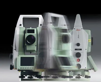
Leica Geosystems says that its TS30 package is a new high precision Total Station that meets highest standards in all surveying applications. Distances can now be measured with Leica Geosystems' proven PinPoint EDM Technology with an unprecedented precision of 0.6mm + 1ppm on prisms. On natural surfaces a high accuracy of 2mm + 2ppm up to 1,000m can be achieved.