
Versilis offers Safety Cloud alerts

Versilis has partnered with Haas Alert to offer motorists Safety Cloud, an infrastructure-to-vehicle (I2V) solution that sends notifications of road layout changes and lane closures
September 3, 2021 Read time: 2 mins
Versilis safety gates are now integrated with Haas Alert’s Safety Cloud, a cellular-V2X (C-V2X) solution that sends real-time digital alerts to drivers

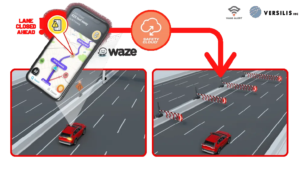
Haas Alert’s Safety Cloud, a cellular-V2X (C-V2X) solution, sends real-time digital alerts to drivers and connected cars to aid drivers in making safer, smarter driving decisions. C-V2X uses 3GPP standardised 4G LTE or 5G mobile cellular connectivity to send and receive signals from a vehicle to other vehicles, pedestrians or to fixed objects such as traffic lights in its surroundings.

Safety Cloud can now be integrated with Versilis’ access control solutions to provide a real-time automotive collision prevention system improving workers’ and motorists’ safety. Safety Cloud delivers notifications to oncoming motorists that Versilis’ automated signs and gates are in a deployed position, indicating a road or lane closure ahead.

When police, firefighters, EMS crews, tow trucks, and other roadway workers are on-scene or en route to a call, nearby drivers receive real-time alerts through navigation apps and vehicle systems delivered via Safety Cloud.

These alerts are received by motorists, connected cars and autonomous vehicles via in-vehicle systems and navigation applications such as WAZE - a GPS navigation software app and a subsidiary of Google - giving drivers clear advance warning and more time to safely slow down and move over. Receiving an advance warning about the nearby roadway hazard reduces the risk of crashes by up to 90%, according to Haas.

WAZE works on smartphones and tablet computers that have GPS support. It provides turn-by-turn navigation information and user-submitted travel times and route details, while downloading location-dependent information over a mobile telephone network.

For more information on companies in this article

Related Content

  • Mobility scooters feature high risks
    April 24, 2024
    Mobility scooters have high risks for users.
  • Topcon’s latest tool for total station connectivity
    April 4, 2017
    Topcon is introducing its MAGNET Construct 2.0 app to deliver connectivity between more instruments. The MAGNET Construct 2.0 is the firm’s next generation app that is intended to drive a wide variety of Topcon total stations from a user’s smartphone or tablet. The first version of the app was purpose-built to drive the LN-100 Layout Navigator system alone. This unit is now available for most Topcon instruments and can run from Android devices or the latest Apple iPhone, iPad, or iPod Touch hardware. Accord
  • Innovative GIS advances from Bluesky
    July 18, 2012
    Aerial survey specialist Bluesky is funding research into the development and use of a new system to map the UK’s cities and towns at night. Bluesky has teamed up with the University of Leicester to look at solutions using new high sensitivity camera sensor technology. Mounted on survey aircraft, the new system can record the location of street lights, illuminated road signs and other night-time sources of light. This can deliver an accurate resource for asset inventories, light pollution assessment and ene
  • Smarter transport solutions from TomTom
    January 4, 2016
    TomTom is introducing two novel products that help deliver smart traffic solutions, RoadDNA and its HAD map. The Road DNA will help make automated driving a reality, according to the firm. Designed with vehicle data storage and processing limitations in mind, RoadDNA delivers highly accurate location information that can easily be integrated into the onboard system of a vehicle. This allows a vehicle to continuously know exactly where it is located on the road. It offers highly accurate vehicle localisa