Versilis offers Safety Cloud alerts

Versilis has partnered with Haas Alert to offer motorists Safety Cloud, an infrastructure-to-vehicle (I2V) solution that sends notifications of road layout changes and lane closures
September 3, 2021 Read time: 2 mins
Versilis safety gates are now integrated with Haas Alert’s Safety Cloud, a cellular-V2X (C-V2X) solution that sends real-time digital alerts to drivers

Haas Alert’s Safety Cloud, a cellular-V2X (C-V2X) solution, sends real-time digital alerts to drivers and connected cars to aid drivers in making safer, smarter driving decisions. C-V2X uses 3GPP standardised 4G LTE or 5G mobile cellular connectivity to send and receive signals from a vehicle to other vehicles, pedestrians or to fixed objects such as traffic lights in its surroundings.

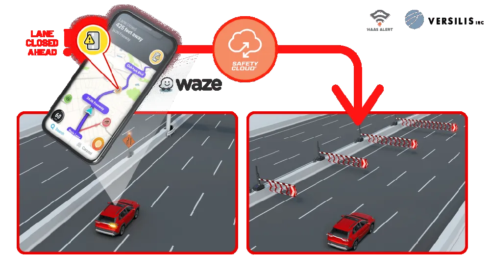
Safety Cloud can now be integrated with Versilis’ access control solutions to provide a real-time automotive collision prevention system improving workers’ and motorists’ safety. Safety Cloud delivers notifications to oncoming motorists that Versilis’ automated signs and gates are in a deployed position, indicating a road or lane closure ahead.

When police, firefighters, EMS crews, tow trucks, and other roadway workers are on-scene or en route to a call, nearby drivers receive real-time alerts through navigation apps and vehicle systems delivered via Safety Cloud.

These alerts are received by motorists, connected cars and autonomous vehicles via in-vehicle systems and navigation applications such as WAZE - a GPS navigation software app and a subsidiary of Google - giving drivers clear advance warning and more time to safely slow down and move over. Receiving an advance warning about the nearby roadway hazard reduces the risk of crashes by up to 90%, according to Haas.

WAZE works on smartphones and tablet computers that have GPS support. It provides turn-by-turn navigation information and user-submitted travel times and route details, while downloading location-dependent information over a mobile telephone network.

For more information on companies in this article

Related Content

  • US road safety record
    April 26, 2012
    The latest official statistics from the US on road accidents show that fatality levels on the nation's roads have dropped to the lowest figures seen for more than six decades. The information was released by US Transportation Secretary Ray LaHood, revealing that highway deaths fell to 32,885 for 2010, the lowest level since 1949.
  • Green light for iRAP's BrazilRAP São Paulo
    June 3, 2024
    BrazilRAP São Paulo will use iRAP’s evidence-based Star Rating methodology to provide an objective rating of the level of safety built in to a road.
  • Drivewyze adds mountain corridor safety alerts for truckers
    September 18, 2019
    The Drivewyze in-cab Safety Notifications Service has added mountain corridor safety alerts to more than 100 locations in 20 US states for truck drivers. Drivewyze, which provides safety and services for connected truck operations, said that its notification service first became available for free to Drivewyze customers at seven mountain pass locations in the state of Colorado last month. Other states now with the service include Arizona, California, Idaho, Massachusetts, New Mexico, Nevada, New York, N
  • Mobile mapping innovation
    June 1, 2022
    There are millions of kilometres of roads and features that need to be mapped in today’s world. We see a strong vision and application for the future, therefore Leica Geosystems, part of Hexagon, recently announced the introduction of the reality capture mobile mapping system Leica Pegasus TRK, introducing artificial intelligence, autonomous workflows and intuitive interfaces. This technology goes beyond the capabilities of what’s already been done, making it the perfect companion for today’s mobile mapping requirements.