Versilis offers Safety Cloud alerts

Versilis has partnered with Haas Alert to offer motorists Safety Cloud, an infrastructure-to-vehicle (I2V) solution that sends notifications of road layout changes and lane closures
September 3, 2021 Read time: 2 mins
Versilis safety gates are now integrated with Haas Alert’s Safety Cloud, a cellular-V2X (C-V2X) solution that sends real-time digital alerts to drivers

Haas Alert’s Safety Cloud, a cellular-V2X (C-V2X) solution, sends real-time digital alerts to drivers and connected cars to aid drivers in making safer, smarter driving decisions. C-V2X uses 3GPP standardised 4G LTE or 5G mobile cellular connectivity to send and receive signals from a vehicle to other vehicles, pedestrians or to fixed objects such as traffic lights in its surroundings.

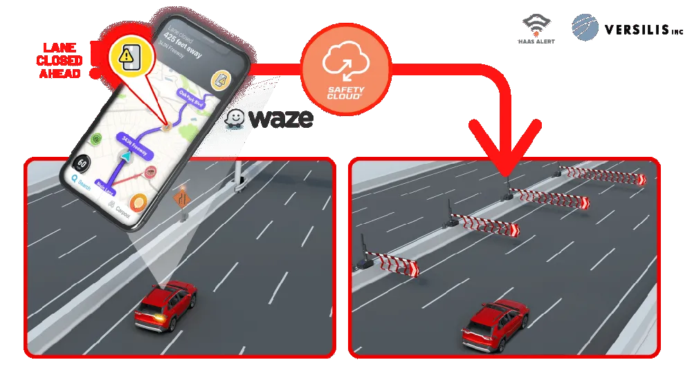
Safety Cloud can now be integrated with Versilis’ access control solutions to provide a real-time automotive collision prevention system improving workers’ and motorists’ safety. Safety Cloud delivers notifications to oncoming motorists that Versilis’ automated signs and gates are in a deployed position, indicating a road or lane closure ahead.

When police, firefighters, EMS crews, tow trucks, and other roadway workers are on-scene or en route to a call, nearby drivers receive real-time alerts through navigation apps and vehicle systems delivered via Safety Cloud.

These alerts are received by motorists, connected cars and autonomous vehicles via in-vehicle systems and navigation applications such as WAZE - a GPS navigation software app and a subsidiary of Google - giving drivers clear advance warning and more time to safely slow down and move over. Receiving an advance warning about the nearby roadway hazard reduces the risk of crashes by up to 90%, according to Haas.

WAZE works on smartphones and tablet computers that have GPS support. It provides turn-by-turn navigation information and user-submitted travel times and route details, while downloading location-dependent information over a mobile telephone network.

For more information on companies in this article

Related Content

  • Proper GPR Surveying Techniques
    May 10, 2019
    A sustainably good road surface often depends on how well understood is the ground underneath the road’s route. Brian Jones* offers some best practice and advice for getting the most from ground-penetrating radar investigations Ground-penetrating radar (GPR) is one of the most accurate non-destructive testing (NDT) methods available. To get the most from GPR surveying, it is absolutely essential to understand how GPR tools work and follow best practices when conducting surveys. Key areas to be aware o
  • More satellites, more signals
    July 20, 2012
    Greater GPS accuracy suggests closer tolerances for surveying and machine control functions What happens in the future for GPS surveying and machine control could depend on satellite choice and signals. Right now there are around 30 satellites in orbit, largely built by the US, but by 2012 that could rise to 120 as Europe, China, India and Russia fully enter the market. A chequered history has faced the European's Galileo system. At long last, the finance appears to be in place and the European Commission a
  • Safe Roads Safe Kids Project: delivering a safe journey to school
    October 15, 2018
    Every year 186,300 children die from road traffic crashes around the world. That is more than 500 children every day. Road traffic injury ranks among the top four causes of death for all children over the age of five years. According to data reported by the Moroccan Comité national de prévention des accidents de la circulation (CNPAC), young people below the age of 14 represent 15% of all the deaths on Moroccan roads and the majority of these are pedestrians. Many of these fatalities are amongst children
  • Work zone safety with SRL's REMOS
    August 11, 2025
    REMOS allows one person off-site to manage several sites simultaneously, efficiently making interventions to prevent and eliminate bottlenecks.