Trimble’s new drone package offers versatility

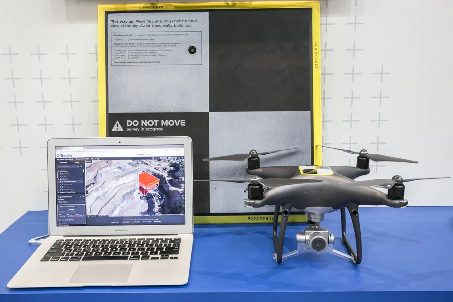
Trimble is now offering a sophisticated new drone package called Trimble Stratus, through the firm’s partnership with drone-mapping and analytics company Propeller Aero. According to Martin Wagener, worldwide product implementation manager for the firm, the system allows the user to employ any type of commercial quality drone. The important part of the package is the Aeropoint, a small flat plate developed by Propellor. This is placed on the ground and acts as a point of reference for all of the drone’s ge
April 26, 2018 Read time: 2 mins
Trimble’s new drone offering can deliver accuracy and versatility
2122 Trimble is now offering a sophisticated new drone package called Trimble Stratus, through the firm’s partnership with drone-mapping and analytics company 8779 Propeller Aero. According to Martin Wagener, worldwide product implementation manager for the firm, the system allows the user to employ any type of commercial quality drone.


The important part of the package is the Aeropoint AeroPoint, a small flat plate ground control point developed by Propeller Aero that makes drone data survey-grade and works with any GPS enabled device. This is placed on the ground and acts as a point of reference for all of the drone’s geolocated images and measurements. The plate features integral GPS and wireless connectivity.
 
The package allows a user to get a comprehensive overview of a project or working area. “You upload all of the pics onto the online Trimble Stratus package and it stitches all the images together to form a digital terrain model. A few hours later you get full pointcloud models from Trimble,” said Wagener.
 
Wagener explained that it requires minimal training to operate, with the complex image data handling task offered as a service by Trimble Trimble Stratus, or its SiTech SITECH dealer network, for the customer.

For more information on companies in this article

Related Content

  • Trimble’s new package boosts piling accuracy; productivity
    October 1, 2014
    Trimble is now offering a dedicated, land-based 3D machine control system for use with a variety of piling machine makes and models. The DPS900 Piling System is said to boost accuracy and allows piling contractors to increase efficiency, taking over from less accurate manual alignment techniques that also take more time for set-up procedures and increase the risk of errors. The firm says that the DPS900 system means contractors can take advantage of accurate positioning and automated reporting to ensure
  • From managed asset to service provider: the future highway
    May 20, 2019
    Every day we hear about Mobility as a Service (MaaS), but what about Roads as a Service? Geoff Hadwick reports from the ERF in Brussels The familiar physical asset called the road will increasingly be seen as part of an emerging global services sector. Given that, the role of the road is changing, notes Christophe Nicodème, general director of the European Union Road Federation (ERF). We need to think much more carefully about planning highway infrastructure in terms of people’s needs, said Nicodème,
  • More satellites, more signals
    July 20, 2012
    Greater GPS accuracy suggests closer tolerances for surveying and machine control functions What happens in the future for GPS surveying and machine control could depend on satellite choice and signals. Right now there are around 30 satellites in orbit, largely built by the US, but by 2012 that could rise to 120 as Europe, China, India and Russia fully enter the market. A chequered history has faced the European's Galileo system. At long last, the finance appears to be in place and the European Commission a
  • Trimble’s tablet offers data processing on-site
    March 12, 2018
    Trimble has developed its T10 Tablet, which the firm claims is a rugged and high-performance data processing platform for use onsite. The unit offers fast computing power and a large screen and is now available through the SITECH dealer channel for use in civil engineering and construction applications. Its key features include a military-grade ruggedness to cope with tough construction site conditions, a sunlight readable display for reading text, graphics and complex maps under field conditions and a