
Trimble is developing smart construction site solutions

Trimble is taking the concept of the building information model (BIM) one stage further with its development of its construction continuum concept. This is intended to show the process and benefits to building a construction-ready model embedded with intelligent data. Such a model can serve as the basis for how contractors plan and execute construction projects. With intelligent modeling, users can add and remove information in real time while simultaneously looking at multiple ways to perform construction
January 6, 2017 Read time: 3 mins
Trimble is taking BIM one stage further
2122 Trimble is taking the concept of the building information model (BIM) one stage further with its development of its construction continuum concept. This is intended to show the process and benefits to building a construction-ready model embedded with intelligent data. Such a model can serve as the basis for how contractors plan and execute construction projects. With intelligent modeling, users can add and remove information in real time while simultaneously looking at multiple ways to perform construction work instead of making manual modifications. The ability to build construction-ready models is significant because it will enable designers and engineers to run multiple scenarios quickly and easily that accurately translate to a constructible model that contractors can effectively build against.

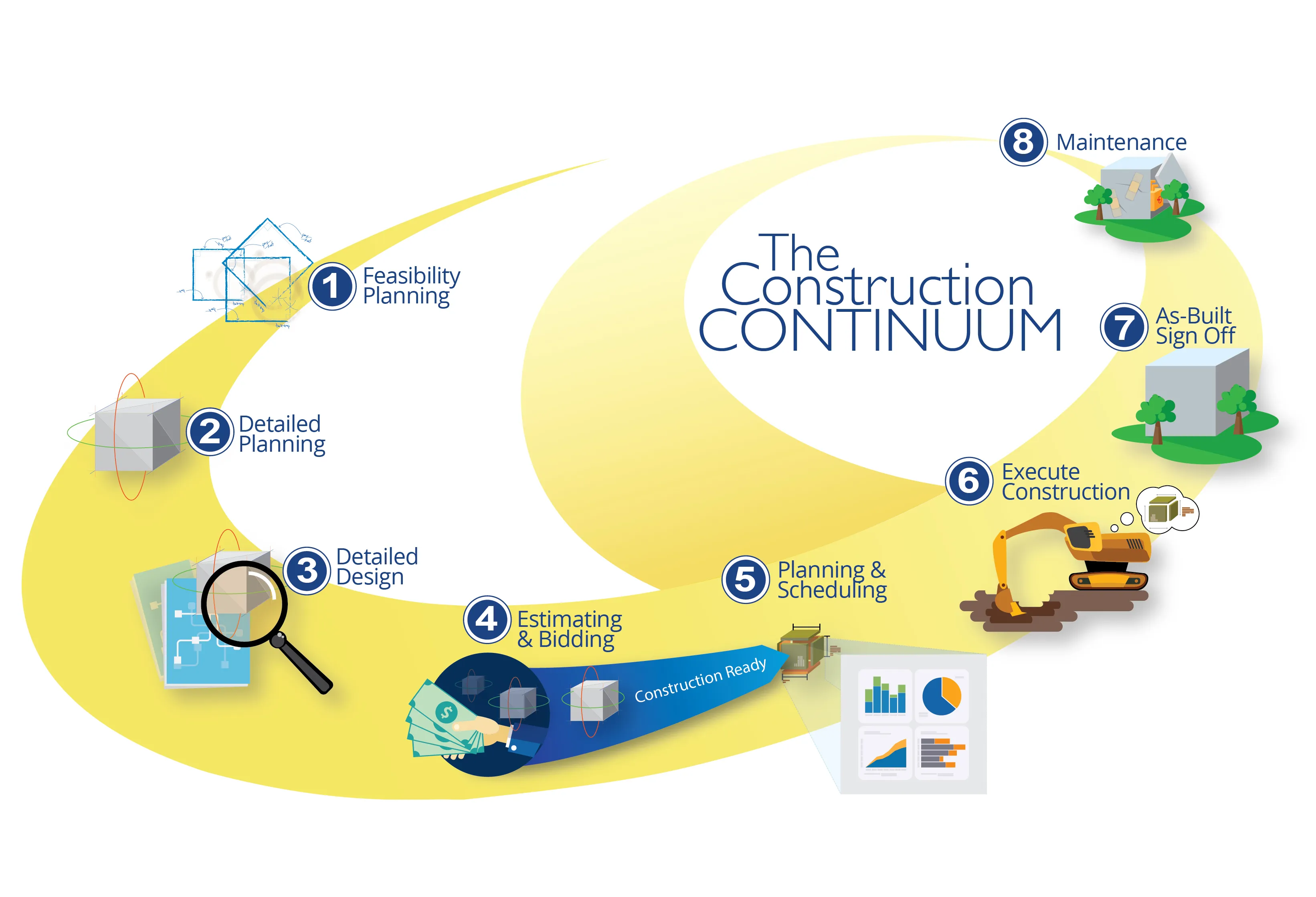
The construction continuum is Trimble’s vision for the construction workflow. This provides a living model with intelligent data that will serve as the foundation for how contractors plan and execute construction projects. This model is used throughout all stages of the project lifecycle, from the first stages of planning and estimating and bidding to detailed construction planning and execution. During this process, it will be continuously updated and enriched with more and more detailed information. Once the construction process is finished, the constructible model also serves as the basis for maintenance work and, eventually, for deconstruction. Through the constant information flow, it becomes a living model, a representation of the structure in the digital space.

The design phase of the continuum constructs in 3D so construction teams are delivered a construction-ready design. A constructible model is built with intelligent data that serves as the foundation of how contractors plan and execute construction projects. With intelligent modeling, users can add and remove information on the fly while looking at multiple ways to perform construction work. Building constructible models allows designers and engineers to run multiple scenarios quickly and easily that accurately translate to a constructible model that contractors can use for building.

Pairing interactive modeling with intelligent data frees engineers and architects to quickly analyse changes and design options in the physical environment. The potential impact is huge for saving time on rework, accelerating the building phase, and producing higher-quality projects.

Trimble also continues to expand its Connected Site capabilities to provide real-time information and data in the field, in the office and throughout the project. This extended capability better enables contractors to achieve faster project completion with reduced costs, improved safety and reduced environmental impact.
All videos

For more information on companies in this article

Related Content

  • Mobile mapping innovation
    June 1, 2022
    There are millions of kilometres of roads and features that need to be mapped in today’s world. We see a strong vision and application for the future, therefore Leica Geosystems, part of Hexagon, recently announced the introduction of the reality capture mobile mapping system Leica Pegasus TRK, introducing artificial intelligence, autonomous workflows and intuitive interfaces. This technology goes beyond the capabilities of what’s already been done, making it the perfect companion for today’s mobile mapping requirements.
  • Apps for all in Louisiana
    May 20, 2020
    Jason Barnes* looks at how a system of engagement (SoE) from software specialist Esri helped the US state of Louisiana’s transportation department create user-friendly apps
  • Asecap Days – Istanbul 2023
    February 16, 2024
    The “vast lakes of data” collected daily by global highway operators are going to waste meaning opportunities to improve services and boost revenue are continually lost. This must change, reports Geoff Hadwick from the ASECAP Days 2023 conference in Istanbul.
  • Innovation in road design and management software
    February 17, 2012
    The emphasis on data processing and re-use, continues to grow in the development of design and management software. The interoperability of software, the need to handle and process larger amounts of data, and re-use and retention of data sets from one task to another have been a growing emphasis in the past few years. It allows infrastructure companies to get better value from expensively collected information and to focus more on the whole life cycle of projects.