Topcon unveils Hybrid Robotic System

Topcon Positioning Group has unveiled its Hybrid Robotic System, featuring the new DS series robotic total station and the recently announced MAGNET v2.0 software suite, a Topcon enterprise solution for the geomatics industry. Other Topcon components in the cutting-edge HRS include the economical HiPer SR GNSS receiver and Tesla large-screen tablet controller. The new system combines GNSS positioning and robotic measurements with an automated data workflow to provide added versatility and efficiency for
January 21, 2014 Read time: 2 mins
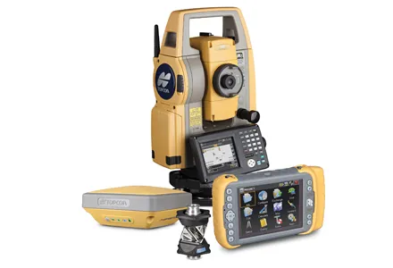
342 Topcon Positioning Group has unveiled its Hybrid Robotic System, featuring the new DS series robotic total station and the recently announced MAGNET v2.0 software suite, a Topcon enterprise solution for the geomatics industry.

Other Topcon components in the cutting-edge HRS include the economical HiPer SR GNSS receiver and 4071 Tesla large-screen tablet controller.

The new system combines GNSS positioning and robotic measurements with an automated data workflow to provide added versatility and efficiency for any measurement or layout job, regardless of job site conditions.

“Topcon’s Hybrid Positioning technology is an innovative and highly productive system that creates an integrated GNSS-robotic rover,” said Scott Langbein, director of product marketing for 7300 Topcon Positioning Systems (TPS).

“The DS robotic total station provides precise measurements anywhere the prism can be seen. When the rover is out of line of sight, GNSS positioning takes over by simply pressing MAGNET’s Hybrid Switch button on the controller,” said Langbein.

“With this versatile system, you can auto-track the prism, use network or an RTK connection,” he said. The system also utilises LongLink communications technology with the HiPer SR, which provides a wireless connection for data transfer, but “with an RTK solution for the HiPer SR, the system performs at maximum versatility on any size job,” added Langbein. If a network RTK solution is not available, using MAGNET Relay, a user can set up an individualised, mobile reference RTK base.

With MAGNET providing the link, the field and office can be connected to exchange files, receive and send messages from crews, and compile and send measurement data to the office.

Hybrid Positioning technology is compatible with other robotic instruments, including the Topcon PS, IS, QS, and Sokkia SX, as well as other GNSS receivers including the Topcon HiPer V, GR-5 (Vanguard), GRS-1 and the Sokkia GRX.

For more information on companies in this article

Related Content

  • Topcon announces increased integration with Autodesk scanning software
    June 2, 2016
    Topcon Positioning Group has announced increased integration in the Autodesk and Topcon reality data workflow that it says is designed to increase project efficiency. Raw scan data from the Topcon GLS-2000 laser scanner can now be taken directly into Autodesk ReCap 360 and ReCap 360 Pro with no intermediate software conversion steps necessary. Topcon said that this integration is designed to streamline point cloud analysis to quickly identify conflicts, measure variations and make adjustments at vari
  • Trimble’s new SitePulse System empowers field managers
    June 9, 2015
    Trimble has launched what it claims is an affordable and easy-to-use site positioning System for superintendents, foremen and field engineers on heavy civil construction sites. Instead of using paper plans, the Trimble SitePulse System empowers field managers with the same 3D constructible model and digital information that is used by construction surveyors, grade checkers and machine operators. Trimble SitePulse field software is ideal for construction managers who do not have a surveying background. The
  • Topcon develops new dozer machine control package
    March 15, 2016
    Topcon Positioning says that its latest indicate dozer machine control system, the i-53, comes with the latest Topcon GNSS receiver, graphical user interface, and machine control software. The firm claims that this package offers a versatile indicate dozer system for an affordable price. The system expands the Topcon dozer indicate product line by offering single GNSS plus single or dual axis slope sensor configurations for complete control of elevation and slope. The i-53 features the Topcon GX-55
  • King of all it surveys
    June 20, 2012
    Topcon Europe Positioning has launched a new total station range to its mid-range engineering grade portfolio. Available in three different angular accuracy models (2.54cms, 7.62cms and 12.7cms), and running the latest version of Windows CE 6.0, the OS Series is said by Topcon to redefine this class of optical measuring device.