
Topcon to smoothen roads with SmoothRide system

Topcon Positioning has developed a sophisticated package that can help deliver better road surface quality. The firm’s latest SmoothRide data collection package is said to make the mapping of road conditions easier and more efficient. The new RD-M1 Collect 2.0 package has an improved interface and a new graphical interface status bar that indicates the optimum speed for collecting road information based on the project requirements.
February 28, 2018 Read time: 2 mins
342 Topcon Positioning has developed a sophisticated package that can help deliver better road surface quality. The firm’s latest SmoothRide data collection package is said to make the mapping of road conditions easier and more efficient. The new RD-M1 Collect 2.0 package has an improved interface and a new graphical interface status bar that indicates the optimum speed for collecting road information based on the project requirements.


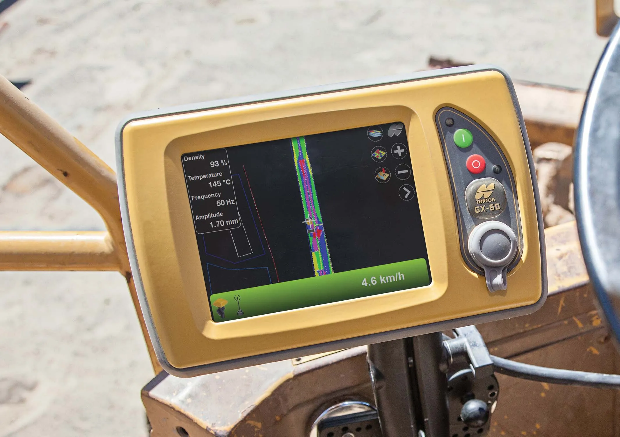
The system provides a steady flow of information about the road surface as the lidar unit scans the whole width of the roadway continuously. The digital design model that is then generated is far more accurate as a result.

Topcon claims that the RD-M1 Collect 2.0 is designed to simplify setup and automatically detect the position of the sensor during data collection. By gathering data at a higher speed, the unit can deliver higher productivity while also delivering better results. The system has a new Memos tool that allows operators to places messages onto the map, while collecting data that also can be made visible in the processing software. This allows specific site conditions to be noted for future reference. Also new is the Manage Runs tool, which means the system can be used without having to open Windows Explorer. Operators can copy data onto a USB drive, delete the information from the hard drive, while the RD-M1 Collect 2.0 Plan Route feature allows for the import of kml files. By using the latest map downloader tool, machine operators can gain access to map details while collecting data, but without the need for an internet connection.

The firm says that using the system for scanning can create a high density point cloud, which the software can then simplify and use to generate a highly accurate digital terrain model. From that the user can develop a new project design, which can then be loaded onto construction equipment for machine guidance purposes.

For more information on companies in this article

Related Content

  • Further new European pavers were launched at bauma 2013
    May 30, 2013
    Earlier this year several manufacturers announced new European asphalt pavers being launched at bauma 2013, but more surprises were in store at the show - Mike Woof writes. At the beginning of 2013 a number of manufacturers revealed new asphalt pavers being launched at the bauma 2013 exhibition. BOMAG, Caterpillar, Vögele and Volvo CE all announced new asphalt pavers in the shape of the BF900, AP300D, -3 Series units and new wheeled P-6870C respectively. These machines were at the show and all attracted con
  • Topcon’s intelligent compaction tool
    September 11, 2014
    Topcon Positioning is introducing the C-63 GPS/GNSS indicator system designed specifically for use with compactors. The package can help deliver precise compaction and features the firm’s novel GNSS technology and graphical display, providing real-time positioning and plan data and ensuring optimum compaction is achieved where required. Compaction is important for soil or asphalt applications but monitoring surfaces is difficult with existing technologies. Over- or under-compaction of asphalt in particular
  • Major advances in compaction technology
    February 9, 2012
    Both soil and asphalt compaction technologies will see key advances in 2010, writes Mike Woof. With each phase of regulations coming into force for engine and noise emissions, as well as operator vibration, manufacturers have been forced to improve, upgrade and update their compaction machines.
  • Efficient asset management delivers
    April 25, 2013
    Maximising the economic benefit of infrastructure assets can be achieved through delivering better quality maintenance. Increasing utilisation of infrastructure follows on from those assets being in better condition. Clearly by tracking infrastructure condition closely, huge gains can be made in addressing technical issues before they become more serious and more costly, as well as minimising disruption. In UK city Birmingham, high resolution aerial photography from Bluesky is helping the city council under