Sokkia has unveiled what it describes as “redefinition of robotics” with its SX series of total stations. The SX series are said to be compact and lightweight systems containing the most modern technology available. Sokkia says the SX’s high-accuracy robotic technology includes an advanced angle measurement system, RED-tech technology, reflectorless EDM, Bluetooth Class 1 long-range data communication, and what is said to be an extremely accurate auto-tracking system using RC-PR5 remote control. Combining t
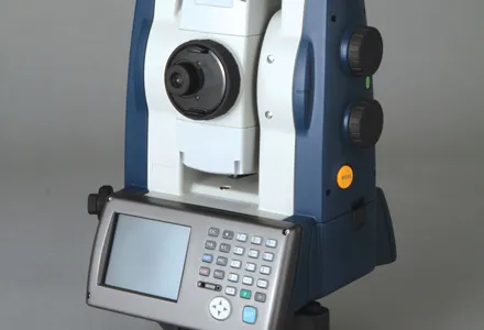
Sokkia has unveiled what it describes as “redefinition of robotics” with its SX series of total stations.
The SX series are said to be compact and lightweight systems containing the most modern technology available.Combining these features with MAGNET Field application software and TSshield, a telematics-based communications module with both cellular technology and GPS for positioning, the SX offers the industry’s most advanced laser and image processing technologies that provide exemplary performance on any job site. From stakeout or boundary work, to landscape projects or forensics, or any project requiring precise 3D positioning, the SX series “provides the best solutions for practically any work requiring fast and accurate measurement,” according to Leighton Davies, survey products sales manager for Sokkia.
In addition to being what Sokkia says is one of the most compact robotic systems available, the SX is cable-free and simple to learn and operate. The fully integrated unit delivers a 304.8m working radius through Bluetooth technology. (All SX data is instantly available at the controller.)
Davies added: “With the SX, reflectorless operation is available up to 1,000m, and fast distance measurement can be accomplished with pinpoint precision is less than a second regardless of object.”
The SX features Sokkia’s original absolute encoders, said to provide long-term reliability in the most adverse job site conditions. Its dual-axis compensator ensures stable measurements even when set up on uneven terrain.
Other features of the SX series include IP65 dustproof and waterproof rating; USB Type A and mini B ports, plus serial port; 25-key pad control panel with LCD touch screen; standard temperature range from -20 to +50 degrees centigrade; and tough metal chassis.