Remote surveying and scanning

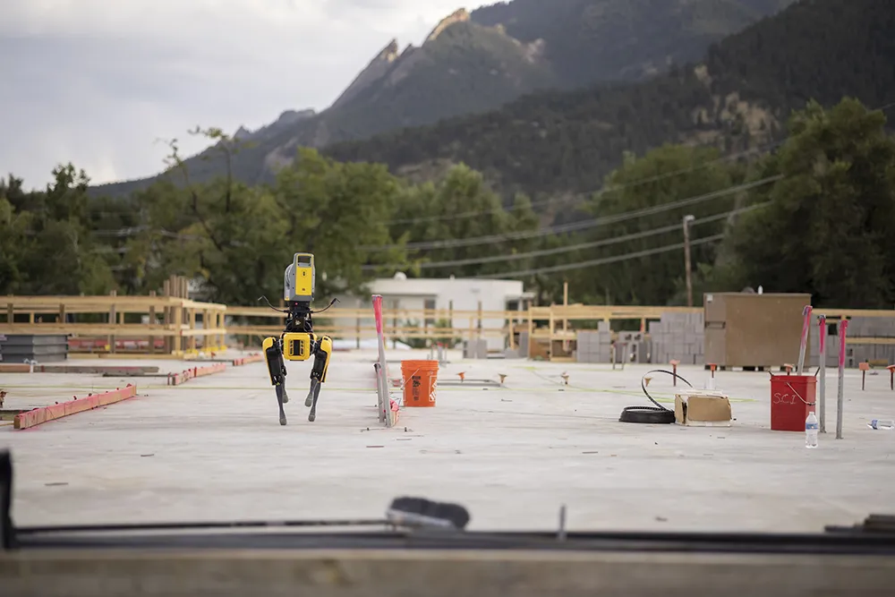
Remote surveying and scanning can be achieved using the autonomous robotic system available from Trimble. The package combines the Spot robot autonomous rover unit with the Trimble X7 3D laser scanner and Trimble FieldLink software.
January 18, 2022 Read time: 2 mins
Autonomous surveying and scanning is possible using the new package from Trimble

This solution has been jointly developed between Trimble and Boston Dynamics and allows autonomous operation on construction sites. The system takes advantage of the robot's ability to navigate challenging, dynamic and potentially unsafe environments. Trimble's 3D data capture technology can deliver a continuous flow of information between the field and the office for documentation of jobsite progress.

The innovative package allows users to make important decisions, rather than waiting for the information to be relayed to project staff. The integration is focused on the automated capture of field construction data through the use of Trimble 3D capture technology and the Spot robot. The autonomous workflow for the X7 laser scanner uses fully integrated Spot robot controls in FieldLink software to create a predefined path of waypoints for Spot to follow and collect laser scans.

Laser scans collected using the X7 scanner and the Spot robot can be tied to a jobsite project coordinate system, as well as individual scan stations. The data is collected, and then made into a composite point cloud in real-time on the Trimble tablet controller before leaving the site. While performing autonomous operations, Spot's docking station enables in-field charging of batteries on both the robot and the X7 3D laser scanner, and also provides the continuous transfer of data through a Gigabit Ethernet connection to the office.

For more information on companies in this article

Related Content

  • Trimble continues to develop connected community portfolio
    April 9, 2013
    Trimble is demonstrating its sophisticated Connected Site portfolio for heavy civil contractors, which connects assets, information, people, machines and sites. This package can meet a vast array of workflow needs of different stakeholders within the contractor’s organisation and meets demand for greater efficiency, shorter completion times and higher quality. Trimble is demonstrating how its Connected Site solutions leverage real-time wireless data flow between the office and job site. This technology allo
  • Field use solutions from mixed-reality
    May 22, 2018
    Trimble is now offering its Connect for HoloLens tool as well as a new hard hat solution for Microsoft HoloLens. According to the firm, the new package improves the utility of mixed-reality for practical field applications. “With the rise in acceptance for mixed-reality solutions in business today, the need for 3D visualisation outside the office is driving this next wave of Trimble innovation," said Aviad Almagor, director of Trimble's Mixed-Reality Program. “We are expanding the opportunities for implemen
  • Trimble’s innovative machine control tools
    June 24, 2024
    Trimble is introducing an array of technology solutions for machine control as well as surveying.
  • More satellites, more signals
    July 20, 2012
    Greater GPS accuracy suggests closer tolerances for surveying and machine control functions What happens in the future for GPS surveying and machine control could depend on satellite choice and signals. Right now there are around 30 satellites in orbit, largely built by the US, but by 2012 that could rise to 120 as Europe, China, India and Russia fully enter the market. A chequered history has faced the European's Galileo system. At long last, the finance appears to be in place and the European Commission a