Remote surveying and scanning

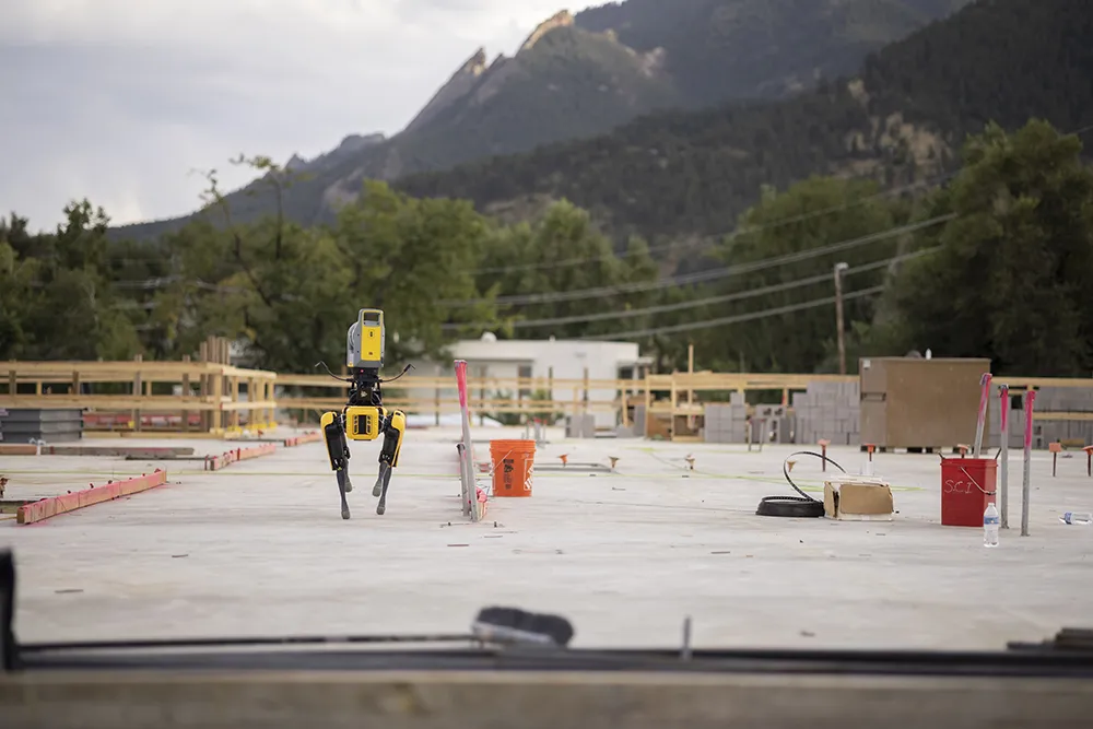
Remote surveying and scanning can be achieved using the autonomous robotic system available from Trimble. The package combines the Spot robot autonomous rover unit with the Trimble X7 3D laser scanner and Trimble FieldLink software.
January 18, 2022 Read time: 2 mins
Autonomous surveying and scanning is possible using the new package from Trimble

This solution has been jointly developed between Trimble and Boston Dynamics and allows autonomous operation on construction sites. The system takes advantage of the robot's ability to navigate challenging, dynamic and potentially unsafe environments. Trimble's 3D data capture technology can deliver a continuous flow of information between the field and the office for documentation of jobsite progress.

The innovative package allows users to make important decisions, rather than waiting for the information to be relayed to project staff. The integration is focused on the automated capture of field construction data through the use of Trimble 3D capture technology and the Spot robot. The autonomous workflow for the X7 laser scanner uses fully integrated Spot robot controls in FieldLink software to create a predefined path of waypoints for Spot to follow and collect laser scans.

Laser scans collected using the X7 scanner and the Spot robot can be tied to a jobsite project coordinate system, as well as individual scan stations. The data is collected, and then made into a composite point cloud in real-time on the Trimble tablet controller before leaving the site. While performing autonomous operations, Spot's docking station enables in-field charging of batteries on both the robot and the X7 3D laser scanner, and also provides the continuous transfer of data through a Gigabit Ethernet connection to the office.

For more information on companies in this article

Related Content

  • Connected Tech for Construction Continuity
    December 11, 2020
    No one could have predicted the situation we found ourselves in in 2020, with a global pandemic bringing the economy to its knees, projects delayed overnight, rapid restarts, remote management, and challenging labor dynamics.
  • Bentley boosts its OpenRoads CONNECT construction software
    November 1, 2016
    Construction software solutions provider Bentley Systems announced that its OpenRoads Designer CONNECT Edition will be available from December. OpenRoads CONNECT Edition is the successor to Bentley’s civil engineering brands InRoads, GEOPAK, MX, and PowerCivil. OpenRoads Designer is a multi-discipline 3D modeling application for roadway projects from conceptual design through construction stages. Bentley Systems said that it “blends traditional engineering workflows for plan, profile and cross-section
  • Machine control technology round table discussion with Leica Geosystems, Topcon and Trimble
    January 4, 2022
    In this, the first in a series of top-level roundtable discussions led by World Highways, editor Mike Woof and editorial director Geoff Hadwick talk machine control technology with three world-class experts from Leica Geosystems, part of Hexagon, Topcon and Trimble. Find out what these key opinion leaders are thinking on six vitally important topics. Let them help you stay ahead of the game.
  • Get paid faster for your work by being efficient, optimised, and careful with resources… get connected now
    September 1, 2023
    In this, the third roundtable meeting in World Highways’ series of Connected Construction discussions, Guy Woodford discusses the implications of developments in artificial intelligence (AI) and machine control with world-class experts in their field. Find out what Elwyn McLachlan, vice president of Civil Solutions at Trimble, Murray Lodge, senior vice president and general manager of Construction at Topcon Positioning Group, and Magnus Thibblin, vice president Heavy Construction at Hexagon Geosystems have to say about how you should be positioning your company for a successful future.