
Proximity alert system from Hexagon boosting site safety

Hexagon’s Leica Geosystems division is now offering an innovative proximity alert package that can help boost site safety. Site personnel and machines carry tags that are recognised by the system and can be identified in the back office. When a site worker comes into proximity with a machine or two pieces of equipment come too close, the system will provide an alert. The tag that the site worker carries will resonate, showing that the person is too close to a working machine. Meanwhile, the alert system in the machine cab will provide a warning to the operator that a person is in the vicinity of the piece of equipment, showing distance as well as direction. Magnus Thibblin, president of the machine control division at Hexagon explained, “The goal is to give the operator visibility of personnel around the machine.”
January 18, 2023 Read time: 2 mins
Hexagon’s Leica Geosystems safety proximity system

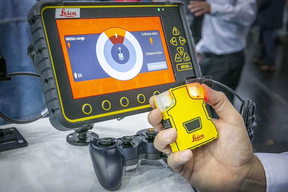
The system offers a range of up to 50m and within this, can be configured by the user with close, near and far alerts to suit the type of operation. This data is recoded in the cloud and Brad Mullins from the firm added, “You can see on a toolbox where there are conflicts.”

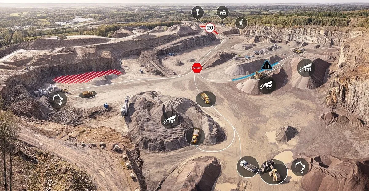
Application engineer Michele Costa said that event logging onsite is sent to the cloud and can be checked on a site map. This shows heat zones of conflicts, identifying machines or personnel and highlighting if there are issues to be resolved such as machines working too close together or obscured sightlines that prevent personnel or machine operators from seeing each other onsite for example. Similarly, for blasting operations on quarries, machines or personnel close to a planned blast can be warned in advance to ensure safety.

For more information on companies in this article

Related Content

  • Precision narrows the gap between design software and GIS
    March 20, 2012
    Greater precision is helping blur the boundaries between GIS technology and design software While GIS map based technology has extended its range across an ever more universal spectrum of uses in the highways sector, it is increasingly showing weaknesses for engineering purposes. It is very often not accurate enough. This has not mattered previously because the GIS tool has been seen essentially as an automated version of paper based systems from the design department's point of view. Where engineers
  • Machine control technology round table discussion with Leica Geosystems, Topcon and Trimble
    January 4, 2022
    In this, the first in a series of top-level roundtable discussions led by World Highways, editor Mike Woof and editorial director Geoff Hadwick talk machine control technology with three world-class experts from Leica Geosystems, part of Hexagon, Topcon and Trimble. Find out what these key opinion leaders are thinking on six vitally important topics. Let them help you stay ahead of the game.
  • Safer construction sites with Leica Geosystems
    April 5, 2024

    A new package from Leica Geosystems is said to help boost safety for personnel on construction sites. The PA10 system is intended to highlight the location of construction personnel on working sites to machine operators, as well as alerting workers as to where equipment is in use.

    “It’s a personal awareness system,” said Thomas Bonvalot of Leica Geosystems. “Everybody onsite will know where a machine is working and the machine operator will know there is a pedestrian.”

  • Safer construction sites with Leica Geosystems
    April 16, 2024
    The PA10 system is intended to highlight the location of construction personnel on working sites to machine operators.