Nikon-Trimble is now offering the new Nikon 25mm and 127mm Total Stations, which are said to deliver improved accuracy over previous products.

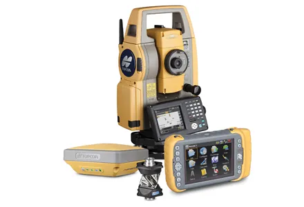
RSS2375 Nikon-Trimble is now offering the new Nikon 25mm and 127mm Total Stations, which are said to deliver improved accuracy over previous products. The new Nikon Nivo 1.C is a high accuracy, reflectorless mechanical total station, while the Nikon DTM-322 is a high value, prism-based 127mm dual-faced total station. Each new model offers high quality optics, performance and reliability and can be used for a variety of surveying applications.
The Nivo 1.C total station complements the existing Nivo C Series surveying solutions and reflects the dependability and reliability represented by the Nikon name. Enabling users to see 12.7mm angular displays, this instrument is said to provide robust locking tangents to ensure quality data. The Nivo Series can provide surveyors with valuable positioning tools to conduct topographic data collection, stakeout or layout jobs, cadastral boundary surveys and more.
Features include a Windows CE touchscreen interface, while field application software functions are provided by the2373 Spectra Precision Survey Pro package for surveying and construction measurement needs. The Nikon total stations provide a long-distance reflectorless measurement range of up to 300m, reducing the need for multiple set-ups. In addition, the Nikon Nivo Series includes a coaxial laser pointer to assist with target identification and reducing aiming time. All Nivo C Series feature a dual-face display, high-precision angle and distance measurements, cable-free Bluetooth connections to external data collectors, support for USB memory sticks, and a high-speed data transfer port. Rugged and durable, the units can operate in virtually all types of weather. Each product supports two interchangeable, onboard batteries that provide up to 62 hours of continuous angle measurements.
The Nivo 1.C total station complements the existing Nivo C Series surveying solutions and reflects the dependability and reliability represented by the Nikon name. Enabling users to see 12.7mm angular displays, this instrument is said to provide robust locking tangents to ensure quality data. The Nivo Series can provide surveyors with valuable positioning tools to conduct topographic data collection, stakeout or layout jobs, cadastral boundary surveys and more.
Features include a Windows CE touchscreen interface, while field application software functions are provided by the