
Precision GNSS surveying

Trimble is widening its radio line-up with the addition of the TDL450H for surveyors. This unit offers long-range capabilities for productive surveys and is designed to support high-precision GNSS surveying applications. The Trimble TDL450H is a 2-35W radio transceiver and enables work in difficult terrain and urban areas. The multi-function user interface streamlines field configuration and troubleshooting so surveyors can maintain productivity.
February 16, 2012 Read time: 1 min
High performance communications can be achieved with the new Trimble radio system
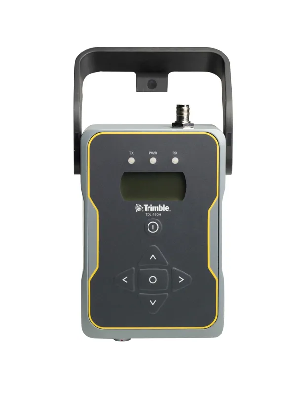
2122 Trimble is widening its radio line-up with the addition of the TDL450H for surveyors. This unit offers long-range capabilities for productive surveys and is designed to support high-precision GNSS surveying applications. The Trimble TDL450H is a 2-35W radio transceiver and enables work in difficult terrain and urban areas. The multi-function user interface streamlines field configuration and troubleshooting so surveyors can maintain productivity. The radio modem allows users to adapt as conditions require: for longer baselines surveyors can dial up the power, and when the work area is smaller, a lower power output can extend battery life. The Trimble TDL450 series is available in two frequency bands to cover the entire commercial UHF band without sacrificing radio performance. It also allows the user to select from either 12.5 or 25kHz channel bandwidth. This high-power radio comes with a new protocol offering 9600bps in a 12.5kHz channel without loss of range.

For more information on companies in this article

Related Content

  • SWARCO FUTURIT's new LED matrix sign
    February 14, 2012
    SWARCO FUTURIT has displayed the latest development of its product range, a full-colour LED matrix sign using a 12mm pixel pitch. The sign, unveiled at the recent Traffex show in Birmingham UK enables ultrahigh resolution of text and graphics so signs can be deployed in lower-speed urban applications without losing legibility and clarity.
  • Leica Captivate Experience works with fifth generation of ATRplus
    August 17, 2015
    Leica Geosystems says its Leica Captivate Experience creates highly realistic 3D models that enables professionals to capture and manage complex data easily and accurately. With little more than a swipe, users can now navigate through customisable apps containing information for multiple projects. Advanced lining and coding provide an interactive 3D model where users can zoom, pan and orbit the rendering for optimal viewing and manipulation. “Leica Geosystems has taken a giant leap forward with Captiv
  • Optimising traffic control ensures efficient use of infrastructure
    April 10, 2013
    Central and local governments are facing many challenges, not least a shortage of funds due to budget restraints in the US and Europe in particular. In other markets, ensuring efficient traffic flow is the priority, with monitoring of network status being a key tool. New technology for traffic monitoring plays a crucial role and the sector is keen to introduce new and more efficient systems. The Transport Research laboratory (TRL) has long been a pioneer of traffic control technologies and its latest MAAPc
  • The concrete option
    July 31, 2012
    Concrete highway construction techniques and technology continues to evolve. Mike Woof reports The recent increases in oil costs are having a knock-on effect for the road construction sector, as asphalt prices have increased noticeably and faster than those for concrete. This has spurred renewed discussion over which construction technique now offers the best long term solution for road building. The debate between those in favour of concrete and those preferring asphalt for highway construction has been on