
Paris traffic management for PTV

The Paris region highway authority has adopted PTV technology, including PTV Flows, to enhance traffic management such as live traffic updates.
September 25, 2023 Read time: 2 mins
Real-time speeds: floating car data is used by PTV’s real-time software to generate highly accurate real-time information that seamlessly integrates with DiRIF's traffic platform, Sytadin (image courtesy PTV Group)

The aim of the contract – following a public invitation to tender - is to supply real-time speed data derived from the GPS location of vehicles travelling on the road network managed by DiRIF - Direction des Routes d'Île-de-France - as well as on certain sections of the Île-de-France region's main road network. The provided data complements and enriches the traffic data available to DiRIF, based on their own detectors.

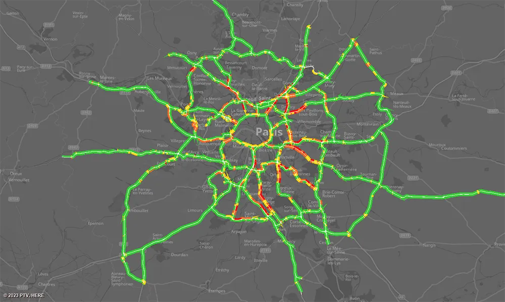
The Paris metropolitan area has 1,300km of highways that are used by more than four million travellers/day. To address numerous bottlenecks and traffic challenges and provide traffic information to road users, DiRIF is offering the online platform sytadin.fr. To further improve the quality of their traffic information and effectively monitor the main road network, DiRIF uses real-time data analytics powered by PTV technology.

DiRIF gathers floating car data (FCD) sourced from TomTom, a Dutch multinational developer of location technology that released its first satellite navigation system in 2004. The data is used by PTV’s real-time software to generate highly accurate real-time information in a four-step process that seamlessly integrates with DiRIF's traffic platform, Sytadin. PTV says that its comprehensive solution significantly enhances the reliability of live traffic updates, allowing DiRIF to inform road users about current traffic conditions, congestion and road closures across the entire Paris metropolitan region.

This is especially important in light of upcoming major international events such as next month’s 2023 Rugby World Cup and the Olympic games next year.

PTV's solution equips DiRIF with the tools to handle the increased demands on the road network effectively, said Frédéric Reutenauer, vice president the Southern Europe region for PTV Group, which is part of Umovity. “Precise data not only reduces delays and enhances safety but also improves the overall efficiency of the transportation system." 

For more information on companies in this article

Related Content

  • Effective demarcation boosts traffic safety
    July 29, 2015
    Effective demarcation can play a crucial role in boosting safety for road users. Good demarcation is vital on a road network to help ensure that drivers stay in the correct lanes and are warned of changes that lie in their path, for example. Road markings are hugely important and for those involved in maintenance, ensuring that these are visible at night and in poor weather can help maximise safety. New technology is on the market now that can help road authorities ensure that road markings meet requirement
  • Eradicating work zone danger
    June 26, 2013
    New safety systems for highway work zones are helping to reduce deaths and injuries in the United States, while much work is being done in Europe to improve work zone safety. Guy Woodford reports. With more road building underway than at any one time in Texas history, the US Lone Star state’s Department of Transportation (TxDOT) is introducing its first highway safety system with queue-warning technology and temporary rumble strips to cut work zone collisions. Debuting along a central Texas stretch of the
  • Optimising operations with construction software gains
    May 20, 2015
    Innovations in construction software are helping boost project efficiency and optimising project operations – Clive Davidson writes Over the past decade, while construction engineers have been putting up buildings or infrastructure, software engineers have been developing a parallel universe where virtual buildings or infrastructure can be created in ever increasing detail. What started with 2D architectural drawings in computer-aided design (CAD) systems, has become a multi-dimensional world, with 3D ge
  • StreetLight Data picks up Minnesota traffic planning contract
    December 14, 2017
    StreetLight Data, a US mobility analytics company, has been selected by the Minnesota Department of Transportation (MnDOT) for a state-wide project.