Paris traffic management for PTV

The Paris region highway authority has adopted PTV technology, including PTV Flows, to enhance traffic management such as live traffic updates.
September 25, 2023 Read time: 2 mins
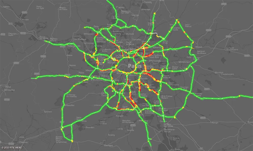
Real-time speeds: floating car data is used by PTV’s real-time software to generate highly accurate real-time information that seamlessly integrates with DiRIF's traffic platform, Sytadin (image courtesy PTV Group)

The aim of the contract – following a public invitation to tender - is to supply real-time speed data derived from the GPS location of vehicles travelling on the road network managed by DiRIF - Direction des Routes d'Île-de-France - as well as on certain sections of the Île-de-France region's main road network. The provided data complements and enriches the traffic data available to DiRIF, based on their own detectors.

The Paris metropolitan area has 1,300km of highways that are used by more than four million travellers/day. To address numerous bottlenecks and traffic challenges and provide traffic information to road users, DiRIF is offering the online platform sytadin.fr. To further improve the quality of their traffic information and effectively monitor the main road network, DiRIF uses real-time data analytics powered by PTV technology.

DiRIF gathers floating car data (FCD) sourced from TomTom, a Dutch multinational developer of location technology that released its first satellite navigation system in 2004. The data is used by PTV’s real-time software to generate highly accurate real-time information in a four-step process that seamlessly integrates with DiRIF's traffic platform, Sytadin. PTV says that its comprehensive solution significantly enhances the reliability of live traffic updates, allowing DiRIF to inform road users about current traffic conditions, congestion and road closures across the entire Paris metropolitan region.

This is especially important in light of upcoming major international events such as next month’s 2023 Rugby World Cup and the Olympic games next year.

PTV's solution equips DiRIF with the tools to handle the increased demands on the road network effectively, said Frédéric Reutenauer, vice president the Southern Europe region for PTV Group, which is part of Umovity. “Precise data not only reduces delays and enhances safety but also improves the overall efficiency of the transportation system." 

For more information on companies in this article

Related Content

  • Innovative utilities approach
    March 20, 2012
    An innovative approach to the management of utilities works is the result of a partnership that has produced the Intelligent Trench. This novel underground mapping solution is also being combined with PelicanCorp's beforeUdig service to deliver a comprehensive and accurate national record-sharing service for underground assets in the UK. The new no-charge service allows local authorities and contractors to use the Intelligent Trench portal to access utility plan information directly from the portal's data b
  • Expanded and branded
    October 4, 2022
    Connected-up cycling is becoming more important in France as the way to keep cyclists from giving up their COVID habit of pedalling to work and for pleasure. David Arminas reports
  • Bentley’s OpenRoads Designer CONNECT Edition Advances Roadway Projects
    November 15, 2016
    OpenRoads’ Comprehensive Modeling Environment Leverages BIM Advancements to Empower Project Delivery LONDON – The Year in Infrastructure 2016 Conference – 1 November 2016 – Bentley Systems, Incorporated, a leading global provider of comprehensive software solutions for advancing infrastructure, today announced that OpenRoads Designer CONNECT Edition will be available for Early Access on December 1, 2016.
  • Nira and Univrses in Swedish road data project
    April 6, 2023
    NIRA Dynamics and Univrses are working on road surface conditions analysis using data from connected vehicles, RWIS, radar/satellite images and weather prognoses to provide a real-time picture of the road status.