Paris traffic management for PTV

The Paris region highway authority has adopted PTV technology, including PTV Flows, to enhance traffic management such as live traffic updates.
September 25, 2023 Read time: 2 mins
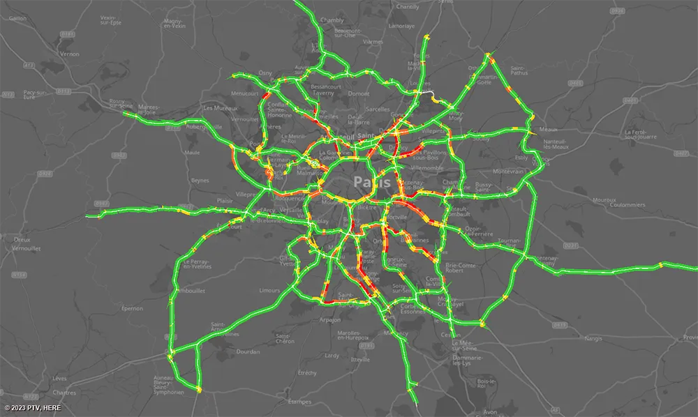
Real-time speeds: floating car data is used by PTV’s real-time software to generate highly accurate real-time information that seamlessly integrates with DiRIF's traffic platform, Sytadin (image courtesy PTV Group)

The aim of the contract – following a public invitation to tender - is to supply real-time speed data derived from the GPS location of vehicles travelling on the road network managed by DiRIF - Direction des Routes d'Île-de-France - as well as on certain sections of the Île-de-France region's main road network. The provided data complements and enriches the traffic data available to DiRIF, based on their own detectors.

The Paris metropolitan area has 1,300km of highways that are used by more than four million travellers/day. To address numerous bottlenecks and traffic challenges and provide traffic information to road users, DiRIF is offering the online platform sytadin.fr. To further improve the quality of their traffic information and effectively monitor the main road network, DiRIF uses real-time data analytics powered by PTV technology.

DiRIF gathers floating car data (FCD) sourced from TomTom, a Dutch multinational developer of location technology that released its first satellite navigation system in 2004. The data is used by PTV’s real-time software to generate highly accurate real-time information in a four-step process that seamlessly integrates with DiRIF's traffic platform, Sytadin. PTV says that its comprehensive solution significantly enhances the reliability of live traffic updates, allowing DiRIF to inform road users about current traffic conditions, congestion and road closures across the entire Paris metropolitan region.

This is especially important in light of upcoming major international events such as next month’s 2023 Rugby World Cup and the Olympic games next year.

PTV's solution equips DiRIF with the tools to handle the increased demands on the road network effectively, said Frédéric Reutenauer, vice president the Southern Europe region for PTV Group, which is part of Umovity. “Precise data not only reduces delays and enhances safety but also improves the overall efficiency of the transportation system." 

For more information on companies in this article

Related Content

  • Europe's smart road pricing project
    February 20, 2012
    New trials pave the way for smart road pricing using Global Navigation Satellite Systems (GNSS). In recent years, the concept of road charging has been gaining acceptability among Europe's policymakers.
  • LA is developed world’s most congested city, new research claims
    July 19, 2012
    Los Angeles is the world’s most congested city, according to new research based on the Tomtom Congestion Index. The city was found to have a congestion level of 33% in the first quarter of 2012. In the Index’s top ten city table, Vancouver in Canada came in second with a 30% congestion level, followed by Miami at 26%. Seattle, San Francisco and Tampa reported congestion levels of 25% each, while Washington and Houston came in seventh and eighth place with congestion levels of 24% and 23% respectively.
  • Trimble’s innovative technology at Conexpo 2014
    January 6, 2017
    The Trimble Quantm alignment planning system allows road designers to reduce planning time and deliver projects with minimal environmental and social impact at a lower construction and operating cost. The system, on show at Conexpo 2014, analyses millions of alignment alternatives and returns a range of options to the planning team for consideration. When new data becomes available the Quantm system can quickly recalculate more alignment options.
  • Trimble’s innovative technology at Conexpo 2014
    January 17, 2014
    The Trimble Quantm alignment planning system allows road designers to reduce planning time and deliver projects with minimal environmental and social impact at a lower construction and operating cost. The system, on show at Conexpo 2014, analyses millions of alignment alternatives and returns a range of options to the planning team for consideration. When new data becomes available the Quantm system can quickly recalculate more alignment options.