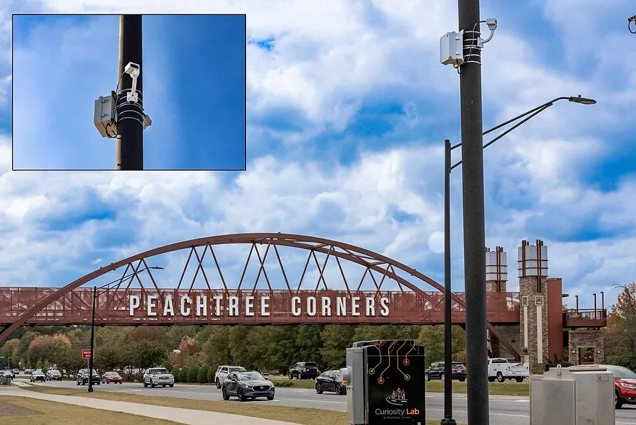
Opsys reports that the first real-world deployment of its pure solid-state LiDAR ALTOS technology has been with the city of Peachtree Corners in the US.
Opsys said that, as a pure solid-state LiDAR, the ALTOS Gen 2 has no moving parts. This enables best-in-class performance with high resolution and extreme reliability with a 4D point cloud from the device’s specific field of view. The pure-solid state characteristics make the unit more robust, avoiding mechanical failures associated with moving components and allowing the unit to have 24/7 operation and pass a 50g shock and full vibration test.
Peachtree Corners announced the collaboration with Opsys, saying it will deploy the company’s Advanced LiDAR Technology Opsys Sensors (ALTOS) Gen 2 LiDAR at Curiosity Lab. The city’s Curiosity Lab - is owned and operated by the City of Peachtree Corners - is a 5G-enabled intelligent mobility and smart city living laboratory located in the southeastern US Atlanta city in Georgia. Designed as a proving ground for IoT, mobility and smart city emerging technologies, the centrepiece of the lab is a three-mile-long (5km) autonomous vehicle lane that uses cellular vehicle-to-everything (C-V2X) technologies.
The ALTOS Gen 2 brings a simple, customisable design to market that can be used for different applications and shapes with a low-power consumption, all without sacrificing performance. “The ALTOS Gen 2 represents the future of smart city technology,” said Rafi Harel, chief executive of Opsys.
“This collaboration with Peachtree Corners and Curiosity Lab gives us the unique opportunity to showcase the reliability and efficiency of our pure solid-state LiDAR technology in a real-world environment, which will soon improve safety and traffic management for cities across the globe,” said Harel. “As our first real-world deployment and first US deployment, we are looking forward to working with Peachtree Corners as our test and demo site to then launch into the US market.”
Opsys said that its new technology boasts a higher partial differential equation (PDE) and a larger array than other models, giving the unit improved detection range and a higher resolution of objects. The improved optics reduce unwanted light, while improving uniformity and enhancing illumination. In addition, the unit’s optimised ASIC/processor allows for advanced processing of data, as well as lower power dissipation and cost.
“Opsys’ technology was extremely easy to calibrate and deploy in our city, said Brandon Branham, executive director of Curiosity Lab. “The simple, yet flexible design made it easy for set up, without the need of special custom cables or proprietary connectors. The device behaves like a normal network device which also made it easy for us to integrate into our single pane of glass smart city management systems. By adding this cutting-edge technology into our infrastructure, we’re able to enhance safety and operational efficiency for our community while showcasing scalable solutions that other cities and industries can easily adopt.”
The ALTOS Gen 2 LiDAR units are deployed at the intersection of State Route 141 and Town Center Boulevard. Here, the ALTOS Gen 2 units provide precise, real-time data on traffic flow and pedestrian movements, offering significant enhancements to urban safety and traffic management. Its ability to operate continuously while supporting PoE - power over ethernet - and auxiliary power, make it adaptable for different municipal implementations and ideal for use across various industries including intelligent traffic systems, smart factories, robotics and public safety applications such as perimeter security and healthcare.