Novel survey solution from Hexagon

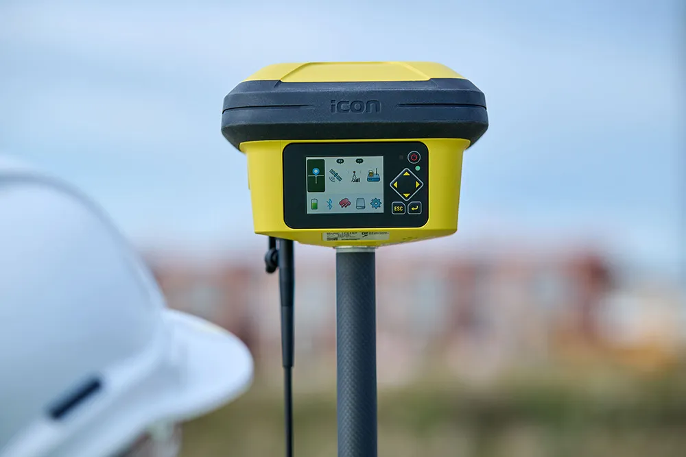
Leica Geosystems, part of Hexagon, says that its Leica iCON gps 160 package is a next-generation construction Smart Antenna with features that increase productivity for stakeout and measurement applications on the jobsite.
January 6, 2023 Read time: 2 mins
Leica iCON gps

The Leica iCON construction portfolio offers a broad range of Smart Antennas to suit all applications according to the firm. The Smart Antennas are said to be able to withstand challenging site conditions. The units integrate with all Leica iCON construction instruments and controllers as well as the iCON field software for precise, real-time verification.

The iCon gps 160 is a versatile solution for various applications. It can be used as a base station, a rover or for machine guidance. The Leica iCON gps 160 is an improved version of the successful Leica iCON gps 60. The result is a smaller, more compact GNSS antenna with additional features and a larger display for ease of use.

Leica Geosystems introduced its safety awareness solution portfolio, including Leica iCON PA10, iCON PA80 and iCON CAS, which addresses the need to immediately warn on- and off-machine field personnel of potential machine-to-people, machine-to-machine and machine-to-object and collisions. As the next step, the company integrates the field-generated safety data into the cloud-based collaboration platform Leica ConX, allowing decision-makers to review incidents and assess the entire operation over time and space. These insights support important safety initiatives by providing visualisation, analysis, monitoring, reporting and data management functions, and address communication and integration needs.

To expand its portfolio of Smart Antennas, Leica Geosystems has launched the iCON gps 160, a versatile solution for various applications. It can be utilised as a base station, a rover or for machine guidance. The Leica iCON gps 160 is a modernisation and enhancement of the successful Leica iCON gps 60, which has been well accepted in the market. The result is a smaller, more compact GNSS antenna with additional features and a larger display for ease of use.
For more information on companies in this article

Related Content

  • French fine milling achieved
    January 10, 2025
    Contractor 2AGE-MCS achieved precision and speed in milling the Route Centre-Europe Atlantique in France with the use of 3D technology
  • More satellites, more signals
    July 20, 2012
    Greater GPS accuracy suggests closer tolerances for surveying and machine control functions What happens in the future for GPS surveying and machine control could depend on satellite choice and signals. Right now there are around 30 satellites in orbit, largely built by the US, but by 2012 that could rise to 120 as Europe, China, India and Russia fully enter the market. A chequered history has faced the European's Galileo system. At long last, the finance appears to be in place and the European Commission a
  • HxGN Live 2014 attracts record event numbers
    August 28, 2014
    Attracting an HxGN Live event record-breaking 3,500 attendees, HxGN Live 2014 held at the MGM Grand in Las Vegas, US, June 2-5 showcased exciting new and in-demand design, measurement and visualisation technologies for industries including road construction and mining. Themed Great Stories Start Here, this year’s event also included a variety of exclusive presentations by industry experts, hands-on training, inspiring keynotes and international networking opportunities. Guy Woodford reports In
  • Innovative GIS software offerings
    July 18, 2012
    The latest construction software developments can speed the construction process overall, Adrian Greeman reports Construction software is by its very nature a very fast moving technology, with new systems coming to the market almost continuously. There are some key developments however, such as major new product launches and market trends. One of the most important developments in the road design sector is the launch of the Bentley Systems V8i versions of its software, including its road design applications