Mobile mapping innovation

There are millions of kilometres of roads and features that need to be mapped in today’s world. We see a strong vision and application for the future, therefore Leica Geosystems, part of Hexagon, recently announced the introduction of the reality capture mobile mapping system Leica Pegasus TRK, introducing artificial intelligence, autonomous workflows and intuitive interfaces. This technology goes beyond the capabilities of what’s already been done, making it the perfect companion for today’s mobile mapping requirements.
June 1, 2022 Read time: 2 mins
Leica Pegasus TRK

The Leica Pegasus TRK solution utilises artificial intelligence capabilities to transform mobile mapping. The advanced dynamic laser scanning and expandible imagery system for recording, measuring and visualising environments increases productivity with automated, intelligent workflows. The Pegasus TRK is so light that it can be operated by one person, making mapping projects more efficient and cost-effective.

Because of the system’s user-friendliness, it is suitable for professionals who are new to the technology. At the same time, its reliable, high-quality deliverables serve the needs of technical experts in various industries, including surveying, transportation and utilities. The Pegasus TRK solution features an AI-enhanced camera and automatic camera calibration. To comply with privacy regulations, its AI can identify and blur identifiers, such as people and vehicles, in real time.

The Pegasus TRK solution enables long-range mobile mapping for applications in asset management; road construction; rail and critical infrastructure; oil, gas and electricity industries and more. The system is also ideal for creating high-definition base maps for autonomous vehicles.

Connect the Pegasus TRK with the new powerful Leica Pegasus FIELD software for fully autonomous and secure data collection and route planning in the field. It also connects with the Leica Cyclone Pegasus OFFICE for seamless input into post-processing and publishing workflows.  

The Pegasus FIELD combines multiple positioning signals from the mobile mapping system, constantly monitors signal quality and availability, checks against system health, battery capacity and storage space. It leverages all of this information to support you in confidently finishing projects successfully.

For mobile mapping professionals across the spectrum - from new entrants to experts - who are looking to apply mobile mapping to a broad range of applications, the Leica Pegasus TRK is an autonomous and intelligent mobile reality capture solution that is characterised by simplicity and ease of use. Unchallenged in performance and accuracy, the Pegasus TRK boosts efficiency from field to office, and is robust and reliable from project planning, data collection, processing through to delivery of a digital twin with an all-new workflow.

Content produced in association with Leica Geosystems

For more information on companies in this article

Related Content

  • Micro-mobility transport solutions under development
    July 24, 2012
    A new report by research specialist Frost & Sullivan suggests that major vehicle producers are working on micro-mobility solutions. The development of these micro-mobility options is being carried out in parallel with that of more conventional four-wheeled vehicles. In all, the report suggests that 25 of the major vehicle manufacturers are working on a total of 150 micro-mobility projects aimed for launch by 2020. These international vehicle firms believe that micro-mobility solutions will suit commuter use
  • The use of concrete cutting tools and tips for users
    October 8, 2015
    Despite the proven importance of identifying metal targets and electrical lines before cutting into concrete, every day there are stories about mishaps that happen when the necessary reconnaissance is not done. In this article, a few firms that provide concrete scanning services weigh in on the critical importance of locating embedded and or buried obstructions by scanning for these features using ground penetrating radar (GPR). Also offered are tips for selecting the best GPR equipment and best practices f
  • More satellites, more signals
    July 20, 2012
    Greater GPS accuracy suggests closer tolerances for surveying and machine control functions What happens in the future for GPS surveying and machine control could depend on satellite choice and signals. Right now there are around 30 satellites in orbit, largely built by the US, but by 2012 that could rise to 120 as Europe, China, India and Russia fully enter the market. A chequered history has faced the European's Galileo system. At long last, the finance appears to be in place and the European Commission a
  • Revealed: Professionals reveal how they are benefiting from building information modelling
    August 9, 2019
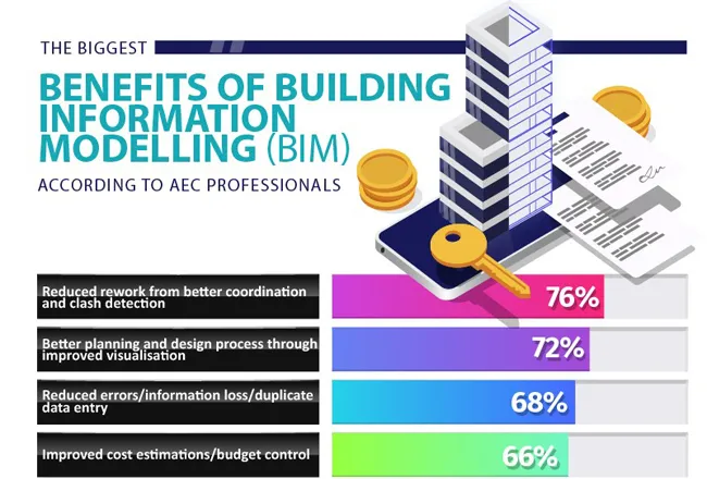
    One of the most important developments in the world of ‘PropTech’ over the last few years has been that of building information modelling (BIM). The technology essentially facilitates architecture, engineering and construction (AEC) professionals to create and use an intelligent 3D model to gain valuable insight into how a building project can be better planned, designed and managed. Interested in ground-breaking ‘PropTech’, housing agents Sellhousefast.uk surveyed 602 architects, engineers and cons