Know what lies below with Leica’s DSX 3D utility detection system

April 11, 2025 Read time: 1 min
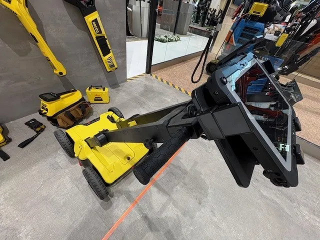
No ordinary lawnmower: utilities can’t hide from Leica Geosystem’s DSX detection solution

Emergency road repair work needn’t create yet another emergency by hitting unknow utility pipes and other systems.  

Leica Geosystems says its DSX utility detection solution can quickly be walked over the area where work is about to start and immediately show an excavator operator any dangers that lie below.

It locates, visualises and map utilities. Unlike any other ground penetrating radar system, the Leica DSX maximises productivity with cutting-edge software that automates data analysis and creates a 3D utility map of the field.

Leica DSX can be used together with Leica GPS/GNSS systems to generate highly accurate georeferenced maps.  

There is also a ‘quick scan’ mode for a quick utility, anomaly and ground condition check before a more detailed grid scan project gets underway.

Operators can add different background layers, such as Google Maps or DXF/DWG.

The solution can export, store, share and access data on major Cloud service providers. It can also maximise troubleshooting efficiency by sharing 
diagnostics data via the Cloud.

For more information on companies in this article

Related Content

  • Efficient asset management delivers
    April 25, 2013
    Maximising the economic benefit of infrastructure assets can be achieved through delivering better quality maintenance. Increasing utilisation of infrastructure follows on from those assets being in better condition. Clearly by tracking infrastructure condition closely, huge gains can be made in addressing technical issues before they become more serious and more costly, as well as minimising disruption. In UK city Birmingham, high resolution aerial photography from Bluesky is helping the city council under
  • Brisbane’s Airport: Innovative Management of One of the World’s Busiest Runways
    June 26, 2014
    When it comes to runways, there are few busier then Brisbane’s main runway. Servicing both domestic and international travel, with over 200,000 movements per year, operating without a curfew Brisbane’s main runway is the busiest in Australia. For maintenance, crews only have a limited period of time to determine the pavement condition, normally during the night, making the detection of pavement faults difficult. To resolve this issue, a new high speed pavement scanner was used to rapidly survey the pavem
  • Data sharing boosts workzone safety
    March 2, 2012
    Faster and safer utilities works are the benefit of innovative data sharing moves – Mike Woof writes
  • Positioning tools continue to improve
    July 16, 2012
    Topcon says that its new IP-S2 package combines GNNS positioning capabilities with inertial sensors, while the firm also has a solution for customers wanting to mix and match receiver components. The IP-S2 is a vehicle-mounted, mobile 3D tool that offers precision mapping and surveying capabilities. The package collects data using 3D laser scanners, LIDAR, and/or cameras, and this is then integrated, time-stamped and geo-referenced. The customer can use this assembled data to combine LIDAR point cloud and d