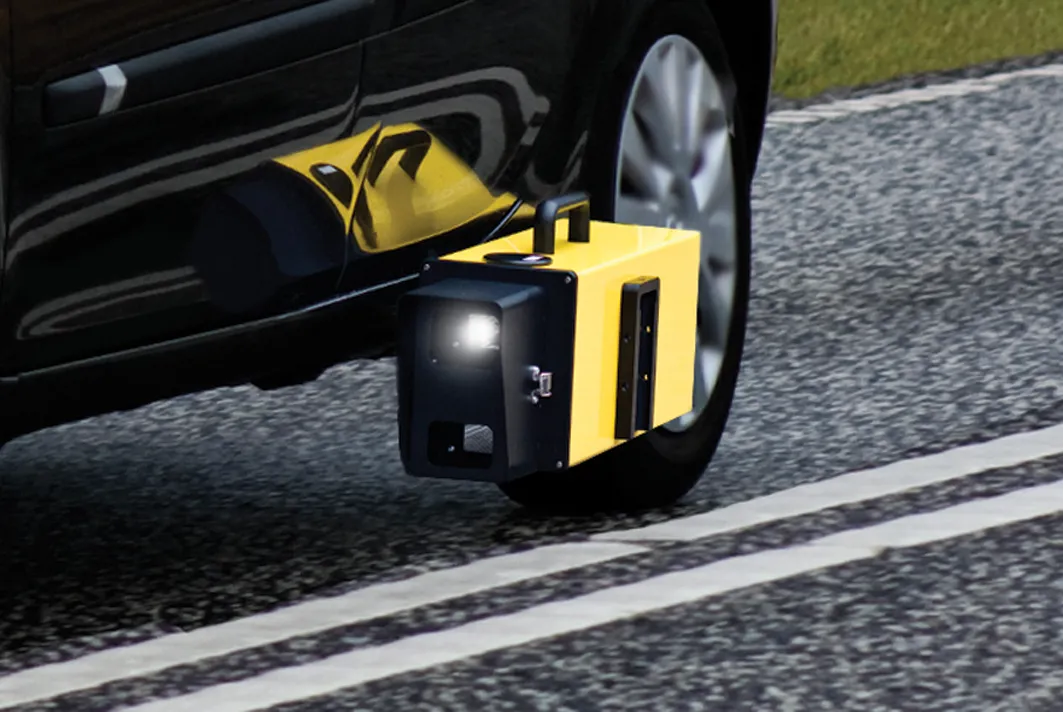
Danish company DELTA has unveiled its new LTL-M mobile retroreflectometer, which it says has taken about four years to develop. The unit, seen at the recent Traffex show in Birmingham, UK, measures all types of road markings at a simulated distance of 30m "with the highest level of accuracy." The company says that the LTL-M is to be used mounted on a vehicle measuring retroreflection at normal traffic speed providing full overview of the condition of the road markings.
DELTA says the instrument operat
Danish company 199 Delta has unveiled its new LTL-M mobile retroreflectometer, which it says has taken about four years to develop.
The unit, seen at the recent346 Traffex show in Birmingham, UK, measures all types of road markings at a simulated distance of 30m "with the highest level of accuracy." The company says that the LTL-M is to be used mounted on a vehicle measuring retroreflection at normal traffic speed providing full overview of the condition of the road markings.
DELTA says the instrument operates with an accuracy of typically +/-5%, which is in line with DELTA's hand-held retroreflectometers LTL-2000, LTL-X and LTL-XL.
It uses the latest camera and illumination technology, which results in high accuracy independent of changes in the geometry of the system through an automatic image process compensating for vehicle movements.
Consisting of three units (the sensor mounted on the outside of the vehicle with camera, flashlight and GPS; processor inside the vehicle; and the graphical user interface/GUI Tablet PC placed next to the driver), the LTL-M was the subject of a study carried out by VTI, the Swedish National Road and Transport Research Institute. The results are reported in Evaluation of the LTL-M, Mobile measurement of road marking, compiled by Sven- Olof Lundkvist in 2010.
The unit, seen at the recent
DELTA says the instrument operates with an accuracy of typically +/-5%, which is in line with DELTA's hand-held retroreflectometers LTL-2000, LTL-X and LTL-XL.
It uses the latest camera and illumination technology, which results in high accuracy independent of changes in the geometry of the system through an automatic image process compensating for vehicle movements.
Consisting of three units (the sensor mounted on the outside of the vehicle with camera, flashlight and GPS; processor inside the vehicle; and the graphical user interface/GUI Tablet PC placed next to the driver), the LTL-M was the subject of a study carried out by VTI, the Swedish National Road and Transport Research Institute. The results are reported in Evaluation of the LTL-M, Mobile measurement of road marking, compiled by Sven- Olof Lundkvist in 2010.