High performance from Topcon’s HiPer XR

April 11, 2025 Read time: 1 min
The lightweight HiPer XR, from Topcon Positioning Systems, Dynamic TILT Compensation technology for effortless measurements, even in difficult conditions

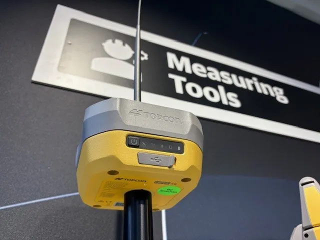
The HiPer XR, from Topcon Positioning Systems, is a robust high-precision GNSS receiver for surveying, construction and geospatial work. It delivers precision and efficiency, tackling all challenges with RTK accuracy and Dynamic TILT Compensation technology for effortless measurements, even in difficult conditions.

Its anti-jamming capabilities ensure reliable performance, while the lightweight, rugged design withstands harsh environments. The HiPer XR is about versatile connectivity with long battery life at an affordable price.

Its multi-constellation support delivers improved accuracy by tracking multiple satellite systems simultaneously, ensuring reliable data even in challenging conditions. With fast charging that reaches 50% in just 30 minutes, downtime is minimised.

TILT technology enables accurate pole-tip measurements without the need for calibration and is also resistant to magnetic interference. Its advanced anti-jamming capabilities ensure reliable signal performance, even in demanding environments.  

Designed to be both durable and lightweight – just under 1kg - it can endure tough conditions while remaining easy to handle.

With support for multiple constellations, flexible connectivity options, and a cost-effective design, the HiPer XR is a practical and adaptable solution for modern surveying needs. 

For more information on companies in this article

Related Content

  • Leica Geosystems develops machine control
    November 29, 2012
    An array of sophisticated machine control and surveying tools are coming to market from Leica Geosystems. One of the key developments is an addition to its iCON range in the form of its iCONtrol package. The firm says that this offers contractors a portfolio of powerful machine control solutions that can communicate with iCONstruct sensors on site and the iCON office software. This customisable and versatile solution suits use in grading and excavating segment and can be used as a control system for constru
  • Spectra Precision introduces new GNSS RTK rover
    January 6, 2017
    Spectra Precision is introducing its sophisticated ProMark 700 system, a GNSS network RTK rover aimed at duties in land survey applications. The unit weighs in at only 650grammes and is said to be the lightest GNSS RTK smart antenna available on the market. Its light weight, together with its compact and slim design, makes the unit the receiver portable and comfortable for field use. It features a long battery life, a rugged, waterproof design and a wide operating temperature range, allowing the ProMark 700
  • Spectra Precision introduces new GNSS RTK rover
    March 8, 2013
    Spectra Precision is introducing its sophisticated ProMark 700 system, a GNSS network RTK rover aimed at duties in land survey applications. The unit weighs in at only 650grammes and is said to be the lightest GNSS RTK smart antenna available on the market. Its light weight, together with its compact and slim design, makes the unit the receiver portable and comfortable for field use. It features a long battery life, a rugged, waterproof design and a wide operating temperature range, allowing the ProMark 700
  • Trimble is launching new machine control technology
    November 9, 2016
    Trimble is introducing a range of new technology options for customers that will boost working efficiency across a range of duties. The firm has also scored a major deal with one of China’s largest equipment manufacturers, XCMG.