Get highly detailed 3D point road surface data from Topcon’s new RD-M2 scanner

April 11, 2025 Read time: 1 min
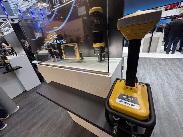
The vehicle-mounted downward-facing RD-M2 from Topcon Positioning Systems delivers precise surface conditions over long and complex roads

Topcon Positioning System’s new RD-M2 laser scanner has been purpose-built for road resurfacing applications.

The vehicle-mounted downward-facing RD-M2 delivers precise surface conditions over long and complex roads, which means no road closures are needed.  

Millions of points are collected by the vehicle operator from safety of his or her cab.

The 3D point data from the RD-M2 scanner serves as the basis for detailed road surface designs using the Topcon Office Suite.  

These ground-truth surfaces are a part of the company’s SmoothRide system workflow.

Users can take advantage of Topcon’s intuitive workflow to create their own custom design from the scan or they can integrate a predefined template.  

Users can also align the scan to the local coordinate system with millimetre-level precision, providing complete flexibility for road resurfacing projects.  

For more information on companies in this article

Related Content

  • Get under the surface of asphalt specification, says Keith Harvey
    July 26, 2018
    Specifiers must do more than just scratch the surface of asphalt specification, urges Keith Harvey* Improving the UK’s road network is a serious business. Amid an escalating population, 2016 saw a colossal 916,000 new vehicles registered in the country. The was a leap of 5% on the year before, bringing the total number of vehicles on our roads to 36.7 million, according to UK government figures. What is perhaps even more concerning, however, is the surge in commercial vehicle use of the network. As he
  • Innovative GIS advances from Bluesky
    July 18, 2012
    Aerial survey specialist Bluesky is funding research into the development and use of a new system to map the UK’s cities and towns at night. Bluesky has teamed up with the University of Leicester to look at solutions using new high sensitivity camera sensor technology. Mounted on survey aircraft, the new system can record the location of street lights, illuminated road signs and other night-time sources of light. This can deliver an accurate resource for asset inventories, light pollution assessment and ene
  • Proper GPR Surveying Techniques
    May 10, 2019
    A sustainably good road surface often depends on how well understood is the ground underneath the road’s route. Brian Jones* offers some best practice and advice for getting the most from ground-penetrating radar investigations Ground-penetrating radar (GPR) is one of the most accurate non-destructive testing (NDT) methods available. To get the most from GPR surveying, it is absolutely essential to understand how GPR tools work and follow best practices when conducting surveys. Key areas to be aware o
  • Machine control partnership between Topcon and Komatsu
    January 6, 2017
    Topcon and Komatsu are gearing up their long running partnership to a new level, and which will be implemented on a global basis. Although the firms have been co-operating internationally for some years, this partnership has been particularly active in the European market for machine control technology. Under the terms of the deal, customers will be able to order Komatsu machines that are factory-fitted with Topcon technology. Sensors will be fitted in the hydraulic rams of bulldozers, graders and excavator