Get highly detailed 3D point road surface data from Topcon’s new RD-M2 scanner

April 11, 2025 Read time: 1 min
The vehicle-mounted downward-facing RD-M2 from Topcon Positioning Systems delivers precise surface conditions over long and complex roads

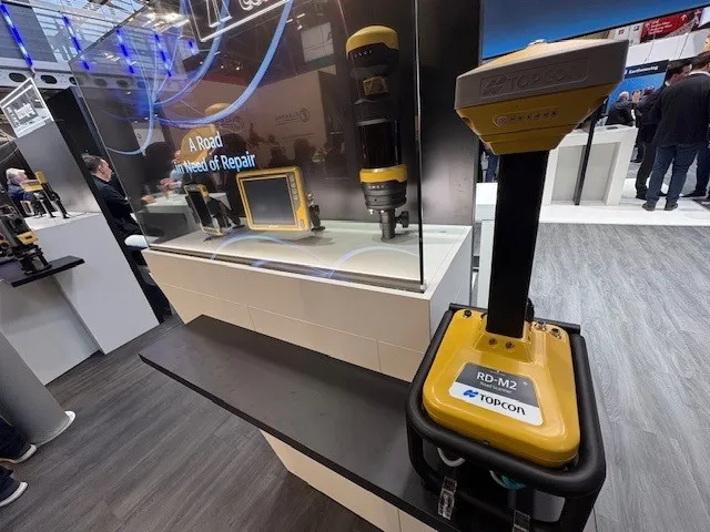
Topcon Positioning System’s new RD-M2 laser scanner has been purpose-built for road resurfacing applications.

The vehicle-mounted downward-facing RD-M2 delivers precise surface conditions over long and complex roads, which means no road closures are needed.  

Millions of points are collected by the vehicle operator from safety of his or her cab.

The 3D point data from the RD-M2 scanner serves as the basis for detailed road surface designs using the Topcon Office Suite.  

These ground-truth surfaces are a part of the company’s SmoothRide system workflow.

Users can take advantage of Topcon’s intuitive workflow to create their own custom design from the scan or they can integrate a predefined template.  

Users can also align the scan to the local coordinate system with millimetre-level precision, providing complete flexibility for road resurfacing projects.  

For more information on companies in this article

Related Content

  • GSSI launches affordable RoadScan 30 GPR road inspection system
    May 11, 2015
    Geophysical Survey Systems (GSSI), a manufacturer of ground penetrating radar (GPR) equipment, has launched a more affordable version of its non-destructive system, called RoadScan 30. The system is designed for measuring pavement thickness, conducting base and sub-base evaluations and measuring available asphalt prior to milling operations. Hundreds of miles of pavement layer thickness data can be collected in a day. RoadScan 30 can collect data densities not obtainable using coring or other labour-i
  • HxGN Live 2014: Leica CEO highlights IT-led road construction and mining gains
    June 4, 2014
    Leica Geosystems’ CEO and president Jürgen Dold has highlighted to HxGN 2014 Live delegates how dynamic geospatial systems are creating more effective and safer workflows on road construction sites and in mining.
  • Topcon: innovation legacy drives democratisation
    February 25, 2025
    Topcon has a legacy of innovation with positioning technologies, and is now translating these groundbreaking inventions into affordable solutions - the democratisation of technology - to meet the needs of clients today. Ray O'Connor, formerly the CEO and President of Topcon Positioning Systems, is now Chairman. He and Ivan Di Federico, who is now President and CEO, explain what it takes to create a future built on a strong heritage. David Arminas reports.
  • Autodesk introduces new software tools
    April 25, 2013
    As World Highways was going to press Autodesk was due to announce the 2014 versions of its entire range of programs including AutoCAD, Civil 3D, NavisWorks and Revit Structural and others programs used by the road industry. As previously, they are packaged in suites; Standard, Premium and Ultimate. Key aspects focus around the inclusion of a completely new and fast point-cloud “engine” developed from the Alice Labs company acquisition made last year. Part of a new Autodesk Recap, standing for reality captur