Get highly detailed 3D point road surface data from Topcon’s new RD-M2 scanner

April 11, 2025 Read time: 1 min
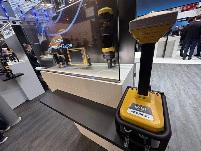
The vehicle-mounted downward-facing RD-M2 from Topcon Positioning Systems delivers precise surface conditions over long and complex roads

Topcon Positioning System’s new RD-M2 laser scanner has been purpose-built for road resurfacing applications.

The vehicle-mounted downward-facing RD-M2 delivers precise surface conditions over long and complex roads, which means no road closures are needed.  

Millions of points are collected by the vehicle operator from safety of his or her cab.

The 3D point data from the RD-M2 scanner serves as the basis for detailed road surface designs using the Topcon Office Suite.  

These ground-truth surfaces are a part of the company’s SmoothRide system workflow.

Users can take advantage of Topcon’s intuitive workflow to create their own custom design from the scan or they can integrate a predefined template.  

Users can also align the scan to the local coordinate system with millimetre-level precision, providing complete flexibility for road resurfacing projects.  

For more information on companies in this article

Related Content

  • Carry on Movin’ On - Michelin’s mobility event
    October 15, 2018
    Many of the great and the good in the global mobility sector gathered at this year’s Movin’ On event in Montreal. Measured regulation of technologies and safety issues were major themes, reports David Arminas Autonomous vehicles, platooning, smart intersections and safety – these were the talking points over two and half days of the Movin’ On event in Montreal. Everyone in the mobility sector is at the same point, trying to see what mobility will look like in the future. Apparent at the event was just
  • Norway’s new ‘green’ highway route
    November 13, 2020
    A new route in Norway will provide a faster and greener highway connection between the capital city Oslo and the northern city of Trondheim
  • Trimble Sketch out major 3D deal
    April 30, 2012
    Trimble has announced a ‘definitive agreement’ to acquire SketchUp, one of the most popular 3D modelling tools in the world, from Google. The major deal is expected to close in the second quarter of 2012, subject to customary closing conditions and expiration of the waiting period under the Hart-Scott-Rodino Antitrust Improvements Act. SketchUp is currently used by millions of users annually—ranging from architects to engineering and construction firms to building and design professionals—for designing, mo
  • Topcon’s SIRIUS PRO is new mapping essential
    May 19, 2014
    Topcon Positioning Group has launched in Europe the Topcon SIRIUS PRO powered by MAVinci, an Unmanned Aerial System (UAS) designed to produce the most accurate solutions for automated mapping of construction sites, pipelines, disaster areas, mines, quarries and myriad sites without regard to terrain.