Get highly detailed 3D point road surface data from Topcon’s new RD-M2 scanner

April 11, 2025 Read time: 1 min
The vehicle-mounted downward-facing RD-M2 from Topcon Positioning Systems delivers precise surface conditions over long and complex roads

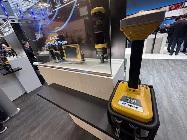
Topcon Positioning System’s new RD-M2 laser scanner has been purpose-built for road resurfacing applications.

The vehicle-mounted downward-facing RD-M2 delivers precise surface conditions over long and complex roads, which means no road closures are needed.  

Millions of points are collected by the vehicle operator from safety of his or her cab.

The 3D point data from the RD-M2 scanner serves as the basis for detailed road surface designs using the Topcon Office Suite.  

These ground-truth surfaces are a part of the company’s SmoothRide system workflow.

Users can take advantage of Topcon’s intuitive workflow to create their own custom design from the scan or they can integrate a predefined template.  

Users can also align the scan to the local coordinate system with millimetre-level precision, providing complete flexibility for road resurfacing projects.  

For more information on companies in this article

Related Content

  • Construction adapting with Machine control Technologies
    June 18, 2015
    Machine control technologies are revolutionising construction – Dan Gilkes writes Electronic control of engines, transmissions and hydraulic systems, primarily to reduce exhaust emissions and boost productivity, is also providing manufacturers with an opportunity to incorporate increasingly complex machine control into their equipment. This in turn has the potential to make the machinery more productive, further cutting fuel consumption as part of a virtuous operational circle.
  • Efficient dozing with Liebherr
    May 31, 2022
    Liebherr’s latest Generation 8 dozers offer a higher level of machine control than ever before
  • Topcon beefs up eXchange AutoCAD 3D civil engineering software
    March 10, 2015
    Topcon’s latest eXchange software add-on for AutoCAD Civil 3D civil engineering design software converts data into files compatible with Topcon 3D construction solutions as well as the MAGNET software system. The add-on even converts complex road designs with defined corridors into Topcon standard file formats, such as MJF (MAGNET Field job) for land surveying and construction layout, and TP3 (3D Topcon Project File) for machine control systems. After installation, users are offered the ability to log in to
  • Sophisticated scanning from Topcon
    August 13, 2019
    Topcon Positioning Group is introducing a new generation of scanning robotic total stations. The firm’s new the GTL-1000 is a compact scanner integrated with a fully featured robotic total station. The firm says that the system is designed to offer a powerful instrument for single-operator layout and scan on a single set up. Combined with the ClearEdge3D Verity package, it offers effective construction verification workflows. The instrument includes a complete robotic total station with layout functionalit