Get highly detailed 3D point road surface data from Topcon’s new RD-M2 scanner

April 11, 2025 Read time: 1 min
The vehicle-mounted downward-facing RD-M2 from Topcon Positioning Systems delivers precise surface conditions over long and complex roads

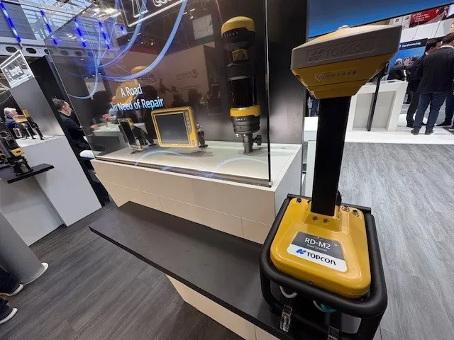
Topcon Positioning System’s new RD-M2 laser scanner has been purpose-built for road resurfacing applications.

The vehicle-mounted downward-facing RD-M2 delivers precise surface conditions over long and complex roads, which means no road closures are needed.  

Millions of points are collected by the vehicle operator from safety of his or her cab.

The 3D point data from the RD-M2 scanner serves as the basis for detailed road surface designs using the Topcon Office Suite.  

These ground-truth surfaces are a part of the company’s SmoothRide system workflow.

Users can take advantage of Topcon’s intuitive workflow to create their own custom design from the scan or they can integrate a predefined template.  

Users can also align the scan to the local coordinate system with millimetre-level precision, providing complete flexibility for road resurfacing projects.  

For more information on companies in this article

Related Content

  • Increased dozing capacity from Caterpillar
    October 9, 2018
    Caterpillar claims that its new D8T Dozer delivers more productivity, better fuel efficiency and greater ease of operation. The firm says that the new dozer is designed to move more material in less time, at a lower cost/tonne, while delivering a faster return on investment. The bulldozer features a new fully automatic transmission, which the firm claims offers a productivity gain of up to 18%, without using more fuel. Added blade capacity, increased power and steering performance, and technology options
  • Versatile wheeled excavator from Doosan
    November 17, 2022
    Doosan is aiming its new DX100W-7 wheeled excavator at duties in urban applications. The firm says that the machine offers compactness and agility, combined with high performance. Weighing 10.7tonnes, this wheeled excavator is the first machine from the firm to compete in the 10tonne wheeled excavator class.
  • Turn drone data into BIM data with DatuBIM
    March 17, 2023
    DatuBIM, from Israel-based Datumate, is a cloud-based SaaS infrastructure data analytics platform that digitises and automates construction work to complete highways and railway projects. It tracks core earthwork progress and execution metrics, detects deviations and prevents expensive rework activity.
  • Trimble technology centre stage at CONEXPO-CON/AGG 2014
    March 27, 2014
    The Trimble Quantm alignment planning system, on show at CONEXPO/CON-AGG 2014, allows road designers to cut planning time and deliver projects with little environmental and social impact at a reduced cost. The system analyses millions of alignment alternatives and returns a range of options to the planning team for consideration. When new data becomes available the Quantm system can quickly recalculate more alignment options.