Get highly detailed 3D point road surface data from Topcon’s new RD-M2 scanner

April 11, 2025 Read time: 1 min
The vehicle-mounted downward-facing RD-M2 from Topcon Positioning Systems delivers precise surface conditions over long and complex roads

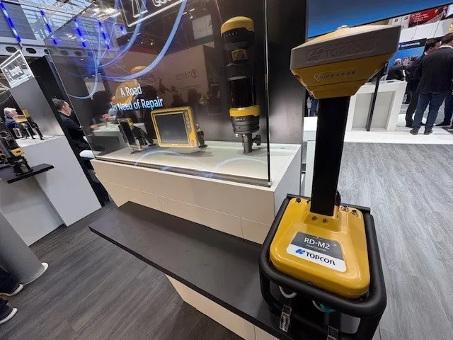
Topcon Positioning System’s new RD-M2 laser scanner has been purpose-built for road resurfacing applications.

The vehicle-mounted downward-facing RD-M2 delivers precise surface conditions over long and complex roads, which means no road closures are needed.  

Millions of points are collected by the vehicle operator from safety of his or her cab.

The 3D point data from the RD-M2 scanner serves as the basis for detailed road surface designs using the Topcon Office Suite.  

These ground-truth surfaces are a part of the company’s SmoothRide system workflow.

Users can take advantage of Topcon’s intuitive workflow to create their own custom design from the scan or they can integrate a predefined template.  

Users can also align the scan to the local coordinate system with millimetre-level precision, providing complete flexibility for road resurfacing projects.  

For more information on companies in this article

Related Content

  • CIFA unveils fully automated shotcrete pump for underground construction 
    October 27, 2022
    CIFA’s new Mamba shotcrete pump is designed for total automation, enabling greater productivity and ensuring safer and easier working conditions for the operator, says the company.
  • Trends in compaction machine technology
    February 20, 2012
    More efficient and productive compaction solutions are coming to market shortly, Mike Woof reports. Several key trends are emerging in the asphalt compaction market with the development of the latest generation machines. Performance and productivity remain key issues for compactor manufacturers with firms keen to maximise output from their latest units.
  • Software developments aids construction projects
    March 21, 2012
    Liebherr claims its wide range of Litronic control system featuring CANUS software ensures construction projects are delivered on time and to budget. The system’s PDE data recording unit logs information such as depth, suspension levels, drilling speed and geometry. It then displays it in real-time via a colour touchscreen in the operator's construction machine cab. Due to constant awareness of the working process, the operator is able to adapt the PDE unit to suit changing environmental conditions. PDE rec
  • Drone system from HCSS
    October 22, 2021
    HCSS says it is offering powerful new features for its HCSS Aerial package, a drone-based data analytics platform. This includes improvements with calculations and measurements, annotation and designs, and navigation. New features are said to optimise tablet performance and improve user experience with the mobile device.