Generate real-world ROI with reality modeling!

Understanding existing site conditions is essential to efficiently design, build, and operate road networks around the world. But how can the real-world be captured quickly and cost-effectively?
September 8, 2022 Read time: 1 min
Courtesy of RS&H

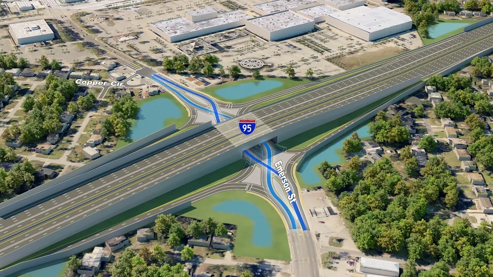
Reality modeling is going mainstream in the transportation industry as it provides real-world digital context for infrastructure projects, enabling organisations to improve worker safety, start projects faster, iterate designs more efficiently, and share information more effectively.

Bentley’s reality modeling software solutions automatically generate high-fidelity 3D reality models from simple photographs and/or point clouds. These reality data can be captured from a variety of devices and techniques, including aerial LiDAR, drone photography, hand-held cameras, terrestrial laser scanners, mobile mapping systems, and even smartphones. The process brings new opportunities to optimize workflows to win projects.

Courtesy of Alabama DOT

You can manage an unlimited number of high resolution photographs, dense point clouds, and panoramic images to gather the information needed to create high-fidelity georeferenced 3D models, reducing health and safety risks for works at dangerous sites. These 3D reality models are quickly generated and available in many formats for users to incorporate into their design, construction, analysis and operation workflows.

Download our e-book and learn how transportation agencies are leveraging reality modeling throughout the asset lifecycle to accelerate the decision-making process and improve team collaboration.

Click here to download our e-book

Content produced in association with Bentley Systems.

For more information on companies in this article

Related Content

  • Innovative GIS advances from Bluesky
    July 18, 2012
    Aerial survey specialist Bluesky is funding research into the development and use of a new system to map the UK’s cities and towns at night. Bluesky has teamed up with the University of Leicester to look at solutions using new high sensitivity camera sensor technology. Mounted on survey aircraft, the new system can record the location of street lights, illuminated road signs and other night-time sources of light. This can deliver an accurate resource for asset inventories, light pollution assessment and ene
  • Break into machine guidance without breaking the bank
    January 10, 2024

    Watch the video

    You don’t get the name “The Dirt Ninja” without a serious obsession with all things heavy equipment and the technologies empowering what’s next for civil construction. For over a decade, Tom Gardocki, co-owner of New Era Excavation, has commanded hundreds of thousands of views on his YouTube channel—with a description that reads, "Anyone can run equipment, very few can operate.” Well said.

  • Cummins at the forefront of power technology
    April 18, 2022
    Cummins has been a leader in the development of innovative power solutions for over 100 years and continues to push the boundaries of technology
  • Trimble machine control technology onsite
    June 3, 2022
    A construction firm in New Zealand is making good use of machine control technology from Trimble. The technology is helping to reduce costs and boost quality, while also addressing the issue of operator skills.