
Construction site visualisation tool

Bentley Systems is now offering its innovative SYNCHRO XR app. This tool is designed for immersively visualising 4D construction digital twins with the new Microsoft HoloLens 2. Bentley has been selected as a Microsoft mixed reality partner and says that using SYNCHRO XR for HoloLens 2, users can interact collaboratively with digital construction models. Users of the tool can utilise gestures to plan, visualise, and experience construction sequencing. Project digital twin data is visualised with the
July 12, 2019 Read time: 2 mins
Using the SYNCHRO XR app
Bentley Systems is now offering its innovative SYNCHRO XR app. This tool is designed for immersively visualising 4D construction digital twins with the new Microsoft HoloLens 2.


6197 Bentley has been selected as a Microsoft mixed reality partner and says that using SYNCHRO XR for HoloLens 2, users can interact collaboratively with digital construction models. Users of the tool can utilise gestures to plan, visualise, and experience construction sequencing.

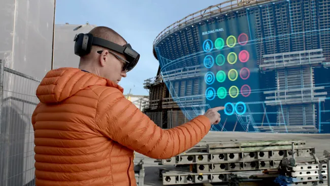
Project digital twin data is visualised with the HoloLens 2 via Bentley’s connected data environment, powered by Microsoft Azure. Construction managers, project schedulers, owner operators, and other project stakeholders can gain insights through immersive visualisation into planned work, construction progress, potential site risks, and safety requirements. Additionally, users can interact with the model together and collaboratively experience 4D objects in space and time, as opposed to traditional interaction with a 2D screen depicting 3D objects.

The Microsoft HoloLens 2 package is a self-contained holographic computer that enables hands-free, heads-up interaction with digital models.

For more information on companies in this article

Related Content

  • Laser scanning focuses on asset management
    January 9, 2015
    Laser scanners and improved data collection and analysis software are making light of asset management surveying. David Arminas reports The age of the laser scanner is upon us, taking over from traditional manual methods of surveying, data collection and processing. These new technical developments are making it much easier to process and use the data captured and are providing highways engineers with powerful tools to record, map and visualise their assets. This is good news for highways authorities
  • Advanced machine control solutions
    February 15, 2012
    Trimble has developed an array of smart solutions for GPS machine control applications, which can now be installed on a wide variety of machines from different manufacturers. The company has long had a close relationship with Caterpillar but can also install units on machines from a range of manufacturers including Case, John Deere, Komatsu, Liebherr, Roadtec and Volvo. The firm's range has developed beyond just the GPS hardware though and includes sophisticated software, which can be loaded onto a hand-hel
  • IRF releases 60th edition World Road Statistics
    November 6, 2023
    The International Road Federation (IRF) has just unveiled the 60th Edition of the IRF World Road Statistics (WRS), the most complete and latest road and transport data.
  • InEight puts project software suite in the cloud
    March 13, 2017
    InEight announced that its Project Suite software will now operate in a cloud environment at CONEXPO-CON/AGG. InEight Project Suite will accept models from any design package and includes modules for estimation, contract management, planning, budget control and inspection. It enables all elements of a project – and the people involved – to be connected in an integrated environment.