Construction site visualisation tool

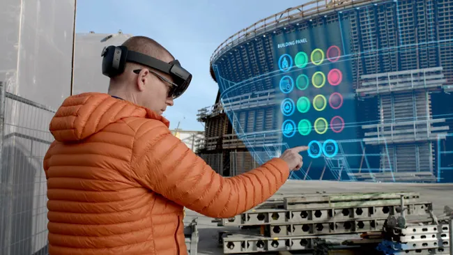
Bentley Systems is now offering its innovative SYNCHRO XR app. This tool is designed for immersively visualising 4D construction digital twins with the new Microsoft HoloLens 2. Bentley has been selected as a Microsoft mixed reality partner and says that using SYNCHRO XR for HoloLens 2, users can interact collaboratively with digital construction models. Users of the tool can utilise gestures to plan, visualise, and experience construction sequencing. Project digital twin data is visualised with the
July 12, 2019 Read time: 2 mins
Using the SYNCHRO XR app
Bentley Systems is now offering its innovative SYNCHRO XR app. This tool is designed for immersively visualising 4D construction digital twins with the new Microsoft HoloLens 2.


6197 Bentley has been selected as a Microsoft mixed reality partner and says that using SYNCHRO XR for HoloLens 2, users can interact collaboratively with digital construction models. Users of the tool can utilise gestures to plan, visualise, and experience construction sequencing.

Project digital twin data is visualised with the HoloLens 2 via Bentley’s connected data environment, powered by Microsoft Azure. Construction managers, project schedulers, owner operators, and other project stakeholders can gain insights through immersive visualisation into planned work, construction progress, potential site risks, and safety requirements. Additionally, users can interact with the model together and collaboratively experience 4D objects in space and time, as opposed to traditional interaction with a 2D screen depicting 3D objects.

The Microsoft HoloLens 2 package is a self-contained holographic computer that enables hands-free, heads-up interaction with digital models.

For more information on companies in this article

Related Content

  • Hamm’s Dr Stefan Klumpp explains future of autonomous compaction
    December 20, 2016
    Autonomous vehicles that can move around without human intervention are not yet a part of everyday life, but they are almost within reach.
  • Sharing point cloud data with Topcon
    March 12, 2018
    A new package from Topcon Positioning Group can help with collaboration and sharing for 3D point cloud data. This web-based service is for integration with the MAGNET Collage desktop mass data processing software — MAGNET Collage Web. According to the firm, the MAGNET Collage Web allows users to access data through a web browser that integrates with the MAGNET Collage Office version. The package means that users can publish and share mass data maps in a user-friendly and intuitive 3D web-based environment
  • Precision narrows the gap between design software and GIS
    March 20, 2012
    Greater precision is helping blur the boundaries between GIS technology and design software While GIS map based technology has extended its range across an ever more universal spectrum of uses in the highways sector, it is increasingly showing weaknesses for engineering purposes. It is very often not accurate enough. This has not mattered previously because the GIS tool has been seen essentially as an automated version of paper based systems from the design department's point of view. Where engineers
  • Bridge of international accord from Russia-China
    May 29, 2018
    A new bridge project joining China and Russia is a sign of international accord between the two nations – Mike Woof writes A new bridge spanning what China calls the Heilongjiang River and which is known as the Amur River in Russia, is a clear sign of an important international accord between the two countries. Discussions over the bridge project were first started between China and Russia in the 1980s, with both nations seeing many changes in leadership since that time. But while the political discussion