Accurate utilities detection

By MJ Woof November 26, 2024 Read time: 1 min
Utility works can be carried out more efficiently using new capabilities offered jointly by Trimble and Radiodetection

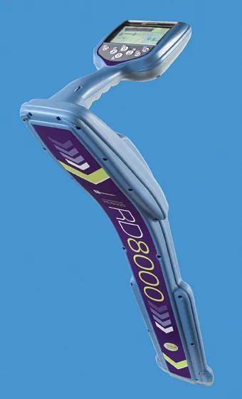
Trimble and Radiodetection are collaborating to improve the technology used in the utility measurement and mapping process. Integrating the Trimble Catalyst DA2 GNSS system and Radiodetection’s RD MapTM+ application and precision locator products helps to streamline utility-locating workflows to provide accurate measurement capabilities and generate underground utilities maps in a single field operation.

When using conventional technology, field technicians mark their measurements onsite or rely on data entries to provide to office staff for map creation after a site visit. However, data collected with the Trimble Catalyst DA2 GNSS system can now be simultaneously synchronised with Radiodetection RD Map+ and precision locators that find and mark buried utilities. By streamlining this connection, workers can digitise utility-line locations and reduce reporting errors. 

“Accurate geolocation is critical to the operation and maintenance of underground utilities and public infrastructure,” said Stephanie Michaud, strategic marketing manager, Trimble Surveying & Mapping Field Solutions. “By adding survey-grade capabilities to existing utility workflows, this collaboration creates a connected solution that provides confidence and reliability during the data capture process.”

The combined technologies provide accurate data for construction firms to work from, assisting with the establishment of dependable digital twins.





For more information on companies in this article

Related Content

  • Control package offerings
    December 15, 2017
    Trimble has established agreements with two more manufacturers of construction equipment with regard to machine control technology, Sumitomo and Yutong. Sumitomo is offering the Trimble Earthworks Grade Control Platform for Excavators as a factory-fit machine control solution for the Japanese market. The solution offers customers two options: 2D Machine Guidance or 2D Machine Control. Both packages can help boost the productivity and quality of earthmoving work. The 2D Machine Guidance option will include
  • Accurate positioning with Leica Geosystems
    June 19, 2017
    The new Zeno GG04 smart antenna from Leica Geosystems is said to increase access to GIS and boost tracking performance. This is said to deliver a versatile solution that can improve the accuracy of GNSS mobile devices with real-time Kinematic (RTK) and precise point positioning (PPP). Paired with the Zeno GG04, any Zeno or third party mobile device with Android or Windows OS can now collect precise positioning data with Leica Geosystems’ GNSS technology and 555-channel tracking performance. With PPP, users
  • Location location
    February 28, 2012
    Improved underground utility location capabilities are claimed for the improved unit from Radiodetection, This new unit is a development of the RD8000 range of pipe and cable locators introduced by Radiodetection in 2008 and offers the addition of an innovative current direction (CD) feature. This is available on Radiodetection's most advanced locator the RD8000PDL and allows a user to trace and identify a target cable in highly congested areas or when running parallel to other lines.
  • Advances in materials testing
    April 10, 2012
    Quicker, better, more cost effective materials testing - Kristina Smith writes. Most developments in materials testing technology involve updating and upgrading existing machines, either to meet changes to standards or to satisfy new needs in the market. And occasionally, a manufacturer will come up with something completely new. PUMA - the precision unbound materials analyser - falls into the latter category. It has been developed by Cooper Research Technology and Nottingham Transportation Engineering Cen