
Accurate data capture with Hexagon

Hexagon is introducing the Leica BLK ARC and the Leica BLK2FLY tools, which offer speed, portability and mobility for autonomous mobile reality capture.
January 2, 2022 Read time: 2 mins
Accurate site evaluation is feasible with Hexagon’s latest technology

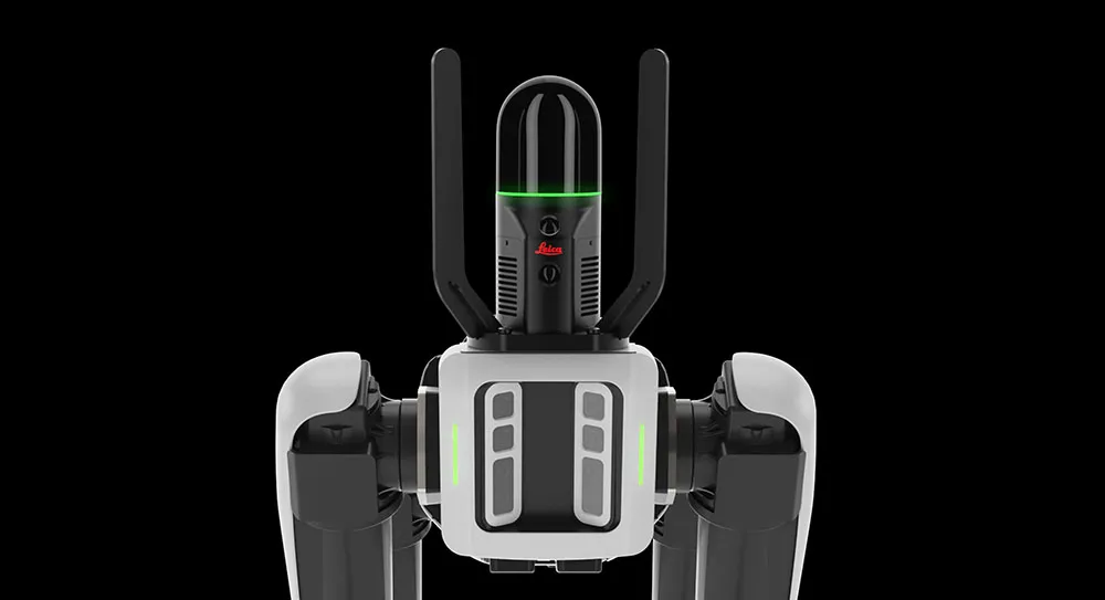
The Leica BLK ARC is a laser scanning sensor designed to improve autonomous navigation of robots and other carrier platforms. Combining speed, accuracy, and versatility with robotics, the BLK ARC offers an autonomous solution that can capture accurate 3D point clouds and panoramic images of changing environments with minimal user intervention.

The Leica BLK2FLY is a fully integrated, autonomous flying laser scanning sensor. Users can use a tablet to scan structures and environments accurately from the air.

The BLK ARC and BLK2FLY tools connect directly to Hexagon’s cloud-based visualisation platform, HxDR, where data uploaded from the field, AI-enabled cloud processing and storage of the captured data allows the delivery of smart digital reality to users.  The BLK ARC can be fitted to the Spot unit from Boston Dynamics Spot but can be integrated with other autonomous robotic carriers. The BLK ARC delivers fully autonomous mobile laser scanning specifically designed for robots. The BLK ARC improves Spot's navigation while capturing 3D data.

The BLK2FLY offers advanced autonomous obstacle avoidance. The system combines LiDAR, radar, cameras, and GNSS for optimal and safe flight paths. Users can combine data from the BLK2FLY with interior scans of buildings and structures captured with the Leica BLK2GO, Hexagon’s handheld 3D scanner. The resulting colourised 3D point clouds are instrumental to building information modelling (BIM) processes, including documenting site conditions.

For more information on companies in this article

Related Content

  • Sophisticated georeferencing technology from Applanix
    November 24, 2020
    Applanix is now offering the Trimble AP+ Air OEM solution for Direct Georeferencing of airborne sensor data.
  • Sophisticated software solutions offering surveying innovation and construction efficiency
    August 28, 2014
    An array of new software tools will deliver greater efficiencies to construction companies – Mike Woof writes. Sophisticated software systems are delivering advanced solutions to traditional construction tasks. Key developments have been made by major players in the sector, such as Bentley Systems, Fugro Roadware, Leica Geosystems and Topcon Sokkia. From Bentley comes a new package that will help road construction activities in urban areas featuring a heavy concentration of underground utilities. This n
  • Bentley Systems launches OpenRoads Designer CONNECT Edition
    April 13, 2017
    The beginning of this year saw Bentley Systems launch a major advanced comprehensive global tool for today’s increasingly widespread BIM environment. Christmas 2016 came early for Bentley's global clients. In fact, they had a hint of what was going to be under their tree come the celebrations in December. On November 1, at Bentley’s annual global client gathering and awards event Year in Infrastructure Conference in London, the solutions provider announced that OpenRoads Designer CONNECT Edition would be a
  • Bentley’s OpenRoads Designer CONNECT Edition Advances Roadway Projects
    November 15, 2016
    OpenRoads’ Comprehensive Modeling Environment Leverages BIM Advancements to Empower Project Delivery LONDON – The Year in Infrastructure 2016 Conference – 1 November 2016 – Bentley Systems, Incorporated, a leading global provider of comprehensive software solutions for advancing infrastructure, today announced that OpenRoads Designer CONNECT Edition will be available for Early Access on December 1, 2016.