Accurate data capture with Hexagon

Hexagon is introducing the Leica BLK ARC and the Leica BLK2FLY tools, which offer speed, portability and mobility for autonomous mobile reality capture.
January 2, 2022 Read time: 2 mins
Accurate site evaluation is feasible with Hexagon’s latest technology

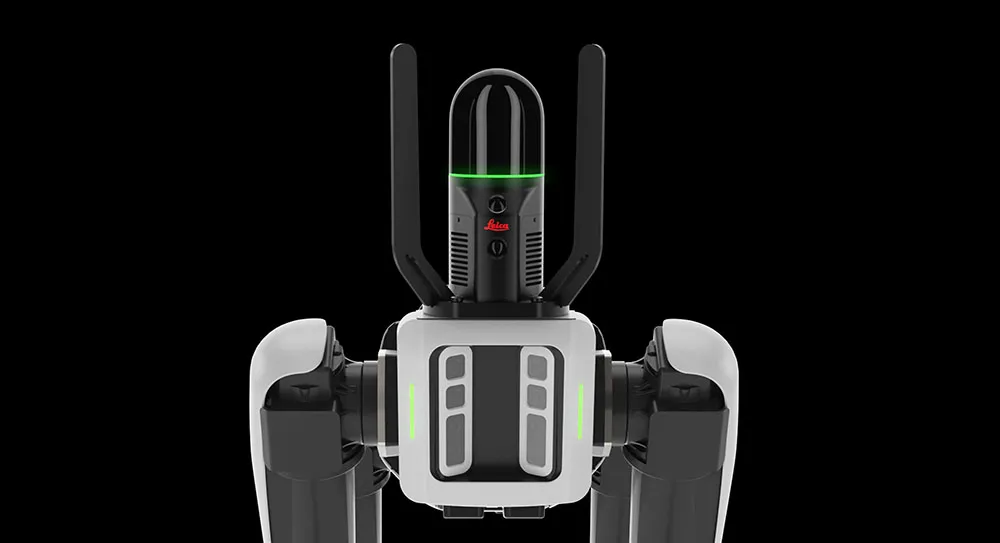
The Leica BLK ARC is a laser scanning sensor designed to improve autonomous navigation of robots and other carrier platforms. Combining speed, accuracy, and versatility with robotics, the BLK ARC offers an autonomous solution that can capture accurate 3D point clouds and panoramic images of changing environments with minimal user intervention.

The Leica BLK2FLY is a fully integrated, autonomous flying laser scanning sensor. Users can use a tablet to scan structures and environments accurately from the air.

The BLK ARC and BLK2FLY tools connect directly to Hexagon’s cloud-based visualisation platform, HxDR, where data uploaded from the field, AI-enabled cloud processing and storage of the captured data allows the delivery of smart digital reality to users.  The BLK ARC can be fitted to the Spot unit from Boston Dynamics Spot but can be integrated with other autonomous robotic carriers. The BLK ARC delivers fully autonomous mobile laser scanning specifically designed for robots. The BLK ARC improves Spot's navigation while capturing 3D data.

The BLK2FLY offers advanced autonomous obstacle avoidance. The system combines LiDAR, radar, cameras, and GNSS for optimal and safe flight paths. Users can combine data from the BLK2FLY with interior scans of buildings and structures captured with the Leica BLK2GO, Hexagon’s handheld 3D scanner. The resulting colourised 3D point clouds are instrumental to building information modelling (BIM) processes, including documenting site conditions.

For more information on companies in this article

Related Content

  • All change – the evolution of data
    January 24, 2018
    Embracing change; handling data as an evolutionary process, Mike Woof writes. Bentley Systems believes that it is on the cusp of a revolutionary step in computing that will boost the working efficiency of companies right across industry. Bhupinder Singh, chief products officer at Bentley Systems explained that its key advance will allow firms to utilise what they already have, but more efficiently. He said, “Companies are effectively analysing just 1% of their data. The rest is ‘dark data’ that is stored
  • Fleeting look at road conditions
    June 16, 2023
    Bridgestone Mobility Solutions has introduced a portfolio of artificial intelligence (AI) data solutions to provide digital insights into road conditions.
  • Efficient stockpile and site monitoring
    October 23, 2017
    Effective monitoring of aggregates stockpiles as well as face excavation can deliver greater quarrying efficiency. One of the latest innovations in quarrying is the use of drones, which provide major benefits for optimising operations. The use of affordable drone hardware and software solutions can help reduce stockpile inventory time by as much as 70%. Through the recent partnership between Trimble and Propeller, drone data can now be an everyday tool in quarries by proving a transformational impact
  • Milling efficiently with machine control
    July 11, 2018
    A contractor in the Netherlands has found that using Topcon’s latest machine control technology can deliver higher quality work at higher productivity The firm, Van Gelder, was looking for a solution to survey, mill and resurface a 7km length of the N518 to the island of Marken more quickly, more safely and more accurately. Together with Infra-Techniek, the company opted to use the latest package developed by Topcon for automatic milling. The N518 from Monnickendam is the only connecting road to the form